.
DOWNLOAD maps from web services.
CONVERT maps for your GPS.
CALCULATE height differences and travel times.
TRANSFER your routes to your GPS.

RECORD the route and points of interest.
USE the on-board computer, compass and augmented reality.
VIEW statistics graphs.
COMPARE the tracks and EVALUATE your performance.


Registration codes are sent by email immediately after purchase.
Please also check junk mail.


What can I do with OkMap?
PRODUCE your own maps
GEOREFERENCE your paper maps.DOWNLOAD maps from web services.
CONVERT maps for your GPS.
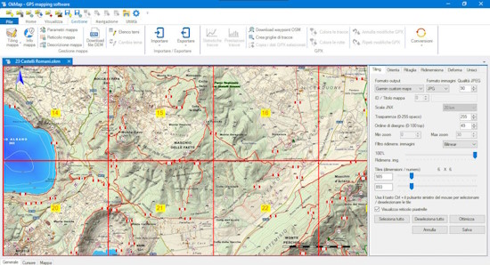
Georeference your paper maps and make them available in your GPS
with OkMap Desktop.
Use a scanner to get your digital maps, preferably in a print shop for better results.
Use OkMap Desktop's calibration function to match each pixel of the map with the corresponding geographic coordinates.
OkMap uses the most popular projection algorithms in the world. It also has a complete list of datums and projections from the official EPSG database.
Get your digital maps from web services available online, automatically georeferenced without any manual operation.
Convert your map to the formats used by portable GPSs (e.g. Garmin) or by Android and iOS apps, including OkMap Mobile.
Read more
Read less
Use a scanner to get your digital maps, preferably in a print shop for better results.
Use OkMap Desktop's calibration function to match each pixel of the map with the corresponding geographic coordinates.
OkMap uses the most popular projection algorithms in the world. It also has a complete list of datums and projections from the official EPSG database.
Get your digital maps from web services available online, automatically georeferenced without any manual operation.
Convert your map to the formats used by portable GPSs (e.g. Garmin) or by Android and iOS apps, including OkMap Mobile.
PLAN your tracks
DRAW your tracks on the maps with the mouse.CALCULATE height differences and travel times.
TRANSFER your routes to your GPS.
Draw your tracks using as
background your digital maps or web maps available online.
Use the different tools available in the software: drawing manual point by point, freehand drawing, automatic routing functions (for road routes).
Edit your tracks with tools that allow the addition or removal of one or more points, the calculation of the inverse track, the union of multiple tracks, the division of a track into multiple tracks, the segments management, the automatic simplification of points, altitudes and much more.
OkMap automatically assigns the altitudes of the track points using the previously downloaded altimetry data (DEM). Automatically calculates travel times using an algorithm which considers your training and the slopes of the track.
Save the trackss and transfer them to your GPS.
Take the recorded trackss from your GPS and load them into OkMap.
Read more
Read less
Use the different tools available in the software: drawing manual point by point, freehand drawing, automatic routing functions (for road routes).
Edit your tracks with tools that allow the addition or removal of one or more points, the calculation of the inverse track, the union of multiple tracks, the division of a track into multiple tracks, the segments management, the automatic simplification of points, altitudes and much more.
OkMap automatically assigns the altitudes of the track points using the previously downloaded altimetry data (DEM). Automatically calculates travel times using an algorithm which considers your training and the slopes of the track.
Save the trackss and transfer them to your GPS.
Take the recorded trackss from your GPS and load them into OkMap.
NAVIGATE along your itineraries
NAVIGATE along your routes without getting lost, you will be notified if you go off course.RECORD the route and points of interest.
USE the on-board computer, compass and augmented reality.
Navigate along your itineraries using OkMap Mobile, an app for Android and iOS.
It is your reliable companion for your outdoor adventures.
Follow your itineraries safely, a warning will tell you if you are going off course.
Use the maps made available by web services or, in the absence of a network, your favorite digital maps produced with OkMap Desktop.
Record the track while you walk a trail and/or follow a trail previously registered or created manually.
View waypoints, tracks and routes on the map; if you are traveling along a path, the recording track is drawn in real time.
An on-board computer will provide you all the information you need, including graphs with slopes and differences in height.
Uses a compass with voice support for pointing and a augmented reality function that displays surrounding waypoints in the camera of the device.
Read more
Read less
Follow your itineraries safely, a warning will tell you if you are going off course.
Use the maps made available by web services or, in the absence of a network, your favorite digital maps produced with OkMap Desktop.
Record the track while you walk a trail and/or follow a trail previously registered or created manually.
View waypoints, tracks and routes on the map; if you are traveling along a path, the recording track is drawn in real time.
An on-board computer will provide you all the information you need, including graphs with slopes and differences in height.
Uses a compass with voice support for pointing and a augmented reality function that displays surrounding waypoints in the camera of the device.
REPORT your performance
PRODUCE track statistics.VIEW statistics graphs.
COMPARE the tracks and EVALUATE your performance.
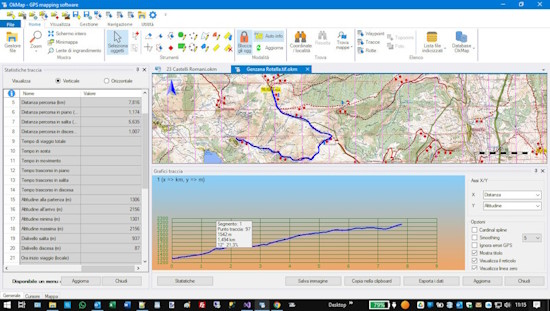
Produce statistics from the tracks drawn or recorded, for
evaluate your performance and performed activities.
View all the important information: distances, times, altitudes, height differences, speed, rates, gradients, calories burned and much more. The software uses algorithms that correctly evaluate differences in height and travel times, consider distances and gradients.
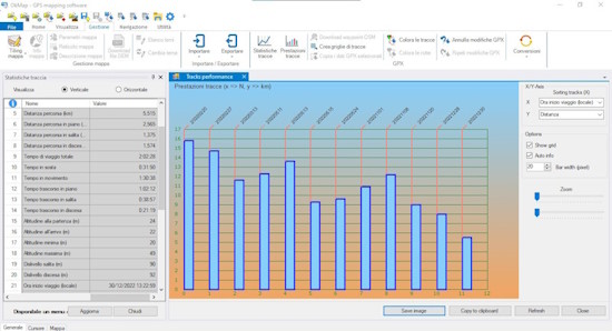
Compare two or more tracks to immediately evaluate, via graphs, your performance trends.
Read more
Read less
View all the important information: distances, times, altitudes, height differences, speed, rates, gradients, calories burned and much more. The software uses algorithms that correctly evaluate differences in height and travel times, consider distances and gradients.
Compare two or more tracks to immediately evaluate, via graphs, your performance trends.
0
0
0
PROJECTION ALGORITHMS
EPSG DATUM
EPSG PROJECTIONS
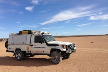
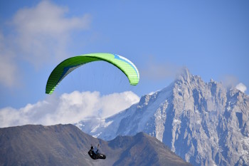
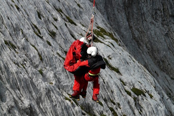
Who is OkMap aimed at?
Download OkMap now!
OkMap Desktop Trial
Windows 7 SP 1 or superior (x64)
Microsoft .NET Framework 4.7.2
1 GHz processor
Minimum RAM 1 GB (2 GB recommended)
Microsoft .NET Framework 4.7.2
1 GHz processor
Minimum RAM 1 GB (2 GB recommended)
OkMap Desktop Full 18.4.1
Registration codes are sent by email immediately after purchase.
Please also check junk mail.
OkMap Mobile
The software can be downloaded directly from the Play Store site for
the Android version and on the Apple Store site for the iOS version.
Please read carefully
Before downloading OkMap, please read the
End User Agreement and the
Terms of Use.
View the list of changes
made to the latest versions of OkMap Desktop.
Contact us for any information
Send us a message
Please before contacting us, also consider the use of forum, you may already find the information you are looking for and other users will be able to participate and contribute with theirs experiences and benefit from the given answers.