GPS Accuracy: errors, precision and signal limitations
Discover how accurate GPS is, which factors affect the accuracy
of GPX tracks, and how to reduce errors during hiking, trekking, and outdoor activities.
Introduction
GPS accuracy is one of the most important aspects of outdoor navigation.
Understanding the origin of positioning errors helps you correctly interpret
GPX tracks,
traveled distances, and elevation data.
Modern GPS receivers are capable of determining a position using
GPS coordinates
with an accuracy of a few meters, but the actual result depends
on many factors: satellite geometry,
natural obstacles, signal reflections, atmospheric conditions, and receiver quality.
During hiking, trekking, mountain biking or outdoor navigation,
these errors can generate noisy GPX tracks, incorrect distances,
imprecise elevations and deviations from the real position.
In this article we analyze the main causes of GPS errors
and see how to improve recording accuracy using
correct techniques and tools such as OkMap.
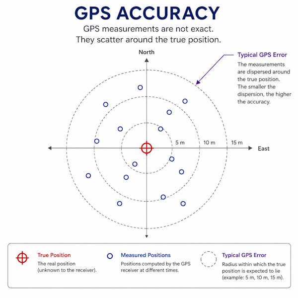
GPS measurements do not match the true position exactly but are distributed around it.
The smaller the dispersion, the greater the positioning accuracy.
Topics covered
Real GPS accuracy
HDOP errors and satellite geometry
Multipath effect
Errors in GPX tracks
Elevation accuracy
Track analysis and correction with OkMap
How accurate is GPS?
Under ideal conditions, a modern consumer GPS receiver can achieve
a typical horizontal accuracy between 3 and 5 meters.
Vertical accuracy is generally worse than horizontal accuracy
and may show errors greater than 10 meters.
Smartphones and smartwatches may also introduce additional errors
due to smaller antennas and power-saving modes.
Satellite geometry and HDOP
The position of satellites in the sky directly affects GPS accuracy.
When satellites are well distributed, positioning becomes more stable.
This parameter is expressed through DOP values
(Dilution Of Precision), including:
HDOP: horizontal accuracy
VDOP: vertical accuracy
PDOP: overall three-dimensional accuracy
Low DOP values indicate better conditions for GPS positioning.
Multipath effect
Multipath occurs when the GPS signal is reflected
by buildings, rock walls, water or metallic surfaces.
The receiver may therefore receive both the direct and reflected signals,
introducing errors in the calculated position.
This problem is particularly evident:
in urban canyons
in dense forests
near rock walls
in narrow valleys
Why do GPX tracks appear noisy?
GPS errors can produce continuous position oscillations,
even when the user is standing still.
This effect generates:
artificial zig-zags
overestimated distances
unstable elevation data
unrealistic tracks
Recordings made in difficult environments may therefore
require corrections or data filtering.
The techniques for cleaning and evaluating recorded data are explained in detail
in the article
Analyzing and Managing GPX GPS Tracks.
How to improve GPS accuracy
Wait a few seconds before starting recording
Keep the receiver with a clear view of the sky
Avoid reflective walls and metallic obstacles
Use multi-constellation GNSS devices
Disable aggressive power-saving modes
Analyzing GPS errors with OkMap
OkMap allows you to display, correct and analyze GPX tracks
using raster maps,
DEMs
and advanced editing tools.
Under ideal conditions, a modern consumer GPS receiver can achieve
horizontal accuracy between 3 and 5 meters. However, actual GPS accuracy
depends on signal quality, satellite visibility,
and the surrounding environment.
What is HDOP?
HDOP (Horizontal Dilution Of Precision) is an indicator of the
geometric quality of satellite distribution. Low HDOP values indicate
better conditions for GPS positioning and greater accuracy
of recorded tracks.
Why can a GPX track contain errors?
GPS errors, natural obstacles, signal reflections (multipath),
insufficient satellite coverage, and atmospheric conditions can
cause deviations, fluctuations, and inaccuracies in GPX tracks.
How can GPS accuracy be improved?
It is advisable to wait a few seconds before starting the recording,
maintain a clear view of the sky, avoid reflective obstacles, and
use multi-constellation GNSS devices. Analyzing GPX tracks
and elevation data can also help identify possible errors.
Summary
GPS accuracy depends on many environmental and technical factors.
Understanding HDOP, multipath, satellite geometry and elevation errors
allows you to better interpret GPX tracks and obtain
more reliable results during outdoor activities.
Do you want to apply these concepts with OkMap?
After reading the technical articles, you can deepen your knowledge with practical video tutorials
or download OkMap Desktop and work directly with maps, GPX tracks and GPS data.