Why a Distance on a Map Can Differ from the Real-World Distance
When we look at a map, we naturally tend to think that every centimetre, every metre of the grid, or every coordinate faithfully represents reality. In fact, the coordinates are correct, but they are represented on a flat surface, whereas the Earth is approximately shaped like an ellipsoid.
To transform a curved surface into a flat one, it is necessary to use a map projection. This transformation cannot preserve distances, areas, angles, and directions simultaneously. Every projection preserves certain properties while inevitably introducing distortions in others.
As a result, the metres shown on the grid belong to the coordinate system of the projection and do not necessarily represent the actual distance measured along the Earth's surface.
A Practical Example
The following image shows a real example observed on a Web Mercator map. Measuring a distance of approximately 10 km along the map grid with the mouse, the corresponding great-circle distance (also called geodetic distance) on the Earth's surface is only about 6.9 km.
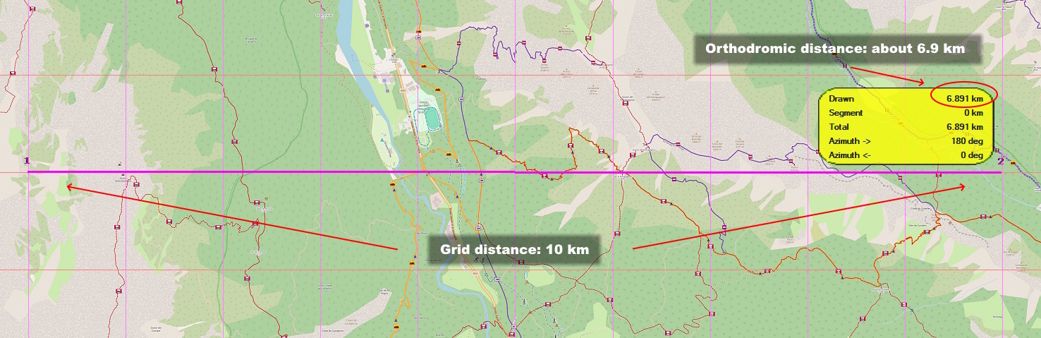
At first glance, the result may seem surprising, but it is perfectly normal. Web Mercator is a conformal projection designed to preserve angles, not distances. As latitude increases, the scale progressively increases, so a given distance represented on the grid corresponds to an increasingly shorter real-world distance.
Why Does This Happen?
The reason lies in the map projection used to represent the Earth's surface. A map is a flat representation of a curved surface, and this transformation cannot preserve all geometric properties at the same time.
Every map projection is designed to preserve certain characteristics at the expense of others. Some preserve angles, others preserve areas, while others aim to minimize overall distortion. However, no projection can represent the Earth perfectly on a flat surface.
For this reason, the map coordinates are correct, but distances measured directly on the grid may differ from the corresponding real-world distances on the Earth's surface.
If you would like to learn more about how map projections work, read the article Map Projections Explained: How to Represent the Earth on a Map.
The metres on the grid belong to the projected coordinate system, not to distances measured directly on the Earth's surface.
Why Does Web Mercator Amplify the Difference?
Web Mercator is currently one of the most widely used map projections for online maps and mapping services because it preserves angles and makes map navigation and visualization simple at different zoom levels.
The trade-off is that the map scale progressively increases with latitude. This means that a given distance represented on the grid corresponds to an increasingly shorter real-world distance as you move away from the equator.
In northern Italy, the difference is already significant, as shown by the Cortina d'Ampezzo example presented earlier. As you move closer to the poles, the distortion becomes even more pronounced.
What About the UTM Coordinate System?
The situation is different with the UTM (Universal Transverse Mercator) coordinate system, which is widely used in technical cartography, hiking, and GPS receivers. UTM was specifically designed to reduce distance distortion within each map zone.
For this reason, a distance measured on the UTM grid is generally very close to the corresponding real-world distance. In most practical applications, the difference is negligible.
However, it is important to remember that even in this case the correspondence is not perfect. Grid distances belong to the projected coordinate system and may show small differences compared with geodetic distances measured on the Earth's surface.
This is why two points separated by approximately one kilometre on the UTM grid are not necessarily exactly one kilometre apart on the Earth's surface, although in practice the difference is usually only a few decimetres or a few metres, depending on the geographic location.
Which Distance Should You Use?
The answer depends on the purpose of the measurement. Grid distance in a map projection and great-circle distance describe two different quantities, and both are correct provided they are interpreted in the appropriate context.
Grid distance is the distance calculated within the coordinate system of the map projection. When expressed in metres, it represents a distance on the projection plane rather than the corresponding real-world distance on the Earth's surface.
Grid distance is useful when working within the coordinate system of the map projection. For example, it can be used to perform calculations directly on projected coordinates or to analyse data expressed in the same reference system.
Great-circle distance, on the other hand, represents the shortest path between two points on the Earth's surface. It is therefore the most appropriate measurement when you need to know the actual distance between two locations, plan a route, or analyse a GPS track.
It is important to remember that these two distances are not alternatives, nor is one more accurate than the other. They simply describe two different quantities, each of which is correct within its own context of use.
How OkMap Handles Distance Measurements
OkMap allows you to measure distances using both the map coordinate system and great-circle calculations on the Earth's surface. This makes it easy to compare the two measurements and understand the effects of the map projection.
When the map uses a projection that introduces significant distortion, such as Web Mercator at medium and high latitudes, the difference between the two measurements becomes immediately apparent. Conversely, with projections designed to reduce distortion, such as UTM, the differences are normally very small.
Understanding this distinction helps you correctly interpret measurement results and avoid drawing incorrect conclusions, especially when comparing data from maps that use different projections.