What Are GPS Coordinates?
A GPS coordinate is a set of numerical values that uniquely identifies a point on the Earth's surface. It is the equivalent of a street address: instead of indicating a street and house number, it mathematically describes the location of a place.
Whenever a GPS receiver determines your position, it returns a pair of coordinates. These coordinates can be expressed in different formats, such as latitude and longitude, UTM coordinates, or other systems used in cartography, military, or scientific applications.
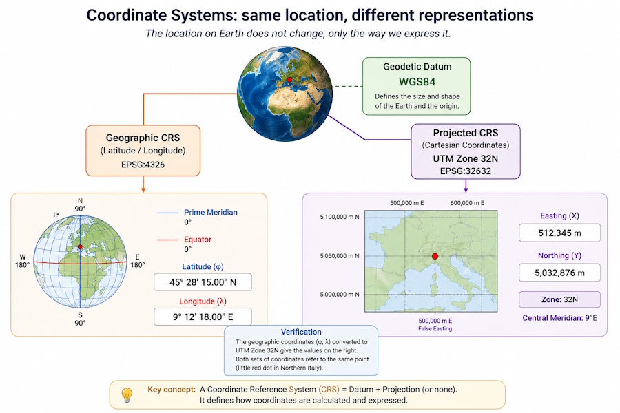
It is important to distinguish between the geographic location and how it is represented. An alpine hut, a mountain summit, or a trail junction has only one position on Earth, but it can be described using different coordinate systems without changing its actual location.
Latitude and Longitude
The most widely used geographic coordinate system uses two values: latitude and longitude. Latitude measures the angular distance from the Equator and ranges from 90° South to 90° North. Longitude measures the angular distance from the Prime Meridian at Greenwich and ranges from 180° West to 180° East.
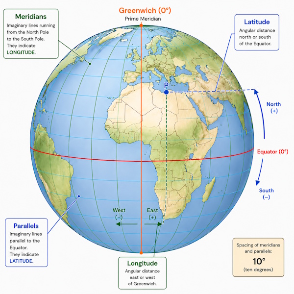
These two coordinates make it possible to identify any point on the planet with great precision and form the system used by the vast majority of GPS receivers and navigation services.
| Coordinate | Reference | Range |
|---|---|---|
| Latitude | Equator | 90° South ÷ 90° North |
| Longitude | Prime Meridian (Greenwich) | 180° West ÷ 180° East |
The accuracy with which a position is identified depends on the number of decimal places used and on the quality of the measurement provided by the GPS receiver.
The WGS84 Datum
Geographic coordinates alone are not sufficient. To correctly represent a point on Earth, it is also necessary to specify the geodetic datum, that is, the mathematical model used to describe the shape and dimensions of the planet.
The datum used by the GPS system is WGS84 (World Geodetic System 1984), now adopted by virtually all satellite navigators, smartphones, and modern mapping services. When a device displays latitude and longitude, in the vast majority of cases those coordinates refer to the WGS84 datum.
It is important to remember that the same point may have slightly different coordinates if it is expressed using different datums. For this reason, mapping software allows you to choose the correct coordinate reference system or perform transformations between different datums.
If you use historical Italian cartography, you may encounter geodetic datums and reference systems other than WGS84, such as Roma40, ED50 or the Gauss-Boaga coordinate system. To learn about the evolution of Italian cartography and understand when these systems are still used, read the article Italian cartography: Gauss-Boaga, Roma40, ED50 and Cassini-Soldner coordinate systems.
How Can Geographic Coordinates Be Expressed?
Geographic coordinates can be represented in different formats while maintaining exactly the same geographic position. Only the way the values are written changes, not the point identified on the Earth's surface.
The three most common formats are Decimal Degrees (DD), Degrees and Decimal Minutes (DDM), and Degrees, Minutes, and Seconds (DMS). All describe the same location and can be converted from one to another without any loss of precision.
| Format | Example |
|---|---|
| Decimal Degrees (DD) | 45.123456°, 11.654321° |
| Degrees and Decimal Minutes (DDM) | 45° 07.407', 11° 39.259' |
| Degrees, Minutes, and Seconds (DMS) | 45° 07' 24.4", 11° 39' 15.5" |
Modern GPS navigators and most mapping software allow you to choose your preferred format. The choice mainly depends on your specific needs or on the conventions used by paper maps and navigation instruments.
Geographic Coordinates and Projected Coordinates
Coordinates based on latitude and longitude describe a position using two angles measured from the Equator and the Greenwich Prime Meridian. For this reason they are called geographic coordinates. Geographic coordinates identify a position on the Earth's surface regardless of the map being used.
In many mapping applications, however, it is more practical to work with coordinates expressed in meters. This is where projected coordinates come into play, obtained by projecting the Earth's surface onto a plane using a specific map projection.
Projected coordinates simplify the calculation of local distances, areas, and directions and are widely used in technical cartography, topographic surveying, and route planning.
UTM Coordinates
The UTM (Universal Transverse Mercator) system, also known as the UTM projection, is one of the most widely used metric coordinate systems in the world. Instead of expressing a location using angles, it uses two values measured in meters: Easting and Northing.
Because it uses meters as its unit of measurement, UTM coordinates are particularly well suited for technical mapping, hiking, land surveying and GIS software. They make it possible to measure distances and areas more intuitively than geographic coordinates expressed in degrees.
To reduce the unavoidable distortions that occur when representing a curved surface on a flat plane, the Earth is divided into 60 UTM zones, each 6 degrees of longitude wide. Each zone has its own independent coordinate system. For this reason, two points located in different UTM zones cannot be compared directly using only their Easting and Northing values.
| Feature | Geographic Coordinates | UTM Coordinates |
|---|---|---|
| Unit of measurement | Degrees | Meters |
| Values | Latitude and longitude | Easting and Northing |
| Typical use | GPS navigation | Cartography, topographic surveying, and measurements |
For this reason, it is always important to know the UTM zone in which the point is located. Easting and Northing values alone are not sufficient to uniquely identify a position.
Datum, Map Projections, and EPSG: Understanding the Differences
These three terms are often confused, but they describe completely different aspects of representing the Earth.
If you would like to explore these topics in greater depth, you can read the articles dedicated to map coordinate systems and map projections, which explain in detail how coordinate reference systems, datums, and the main map projections used in cartography work.
| Concept | What it describes |
|---|---|
| Datum | The mathematical model of the Earth used to calculate coordinates. |
| Map projection | The method used to represent the Earth's surface on a flat plane. |
| EPSG code | The numeric identifier of a coordinate reference system. |
A datum defines the Earth's mathematical model, a map projection determines how it is represented on a flat plane, while an EPSG code identifies a specific coordinate reference system. These are three related concepts, but they are not equivalent.
The most widely used datum in satellite navigation is WGS84, while the UTM projection is one of the most common methods for converting geographic coordinates into projected coordinates.
An EPSG code is not a coordinate system, but simply a numeric identifier assigned to a specific coordinate reference system. For example, EPSG:4326 identifies the WGS84 geographic coordinate system expressed in latitude and longitude, while EPSG:32632 identifies the WGS84 / UTM Zone 32N coordinate system. There are thousands of EPSG codes, each associated with a specific coordinate reference system.
Using the correct EPSG code allows mapping software to correctly interpret coordinates and automatically transform them between different coordinate reference systems, avoiding positioning errors.
Many Coordinate Systems, One Geographic Location
One of the most important concepts to understand is that a location on the Earth's surface can be represented using many different coordinate systems. Latitude and longitude, UTM, MGRS, Open Location Code, and many other systems simply describe the same point using different conventions.
OkMap supports many coordinate systems in addition to traditional geographic and UTM formats, including ECEF, GeoRef, MGRS, USNG, British National Grid, Irish Grid, Open Location Code, and projected coordinates based on the current map projection. For most hiking, cycling, and navigation applications, however, geographic coordinates and the UTM system remain the most widely used solutions.
Other Coordinate Systems Supported by OkMap
In addition to geographic coordinates and the UTM system, there are many other coordinate reference systems used in specialized fields such as geodesy, aviation, national cartography, and military applications. Although they are less common in hiking and outdoor navigation, it is useful to be aware of their existence.
| System | Typical use |
|---|---|
| Decimal Degrees (DD) | GPS, smartphones, and general mapping. |
| Degrees and Decimal Minutes (DDM) | Marine navigation and many GPS receivers. |
| Degrees, Minutes, and Seconds (DMS) | Traditional cartography. |
| UTM | Topographic surveying, GIS, and technical mapping. |
| ECEF | Geodesy and satellite navigation. |
| MGRS | Military and NATO applications. |
| USNG | U.S. civilian mapping. |
| GeoRef | Aviation. |
| Open Location Code (Plus Code) | Identifying locations without street addresses. |
| British National Grid | United Kingdom mapping. |
| Irish Grid | Irish mapping. |
| Projected coordinates | Current map projection. |
OkMap can display, convert, and use all these coordinate systems, allowing you to work with maps from different sources without losing accuracy.