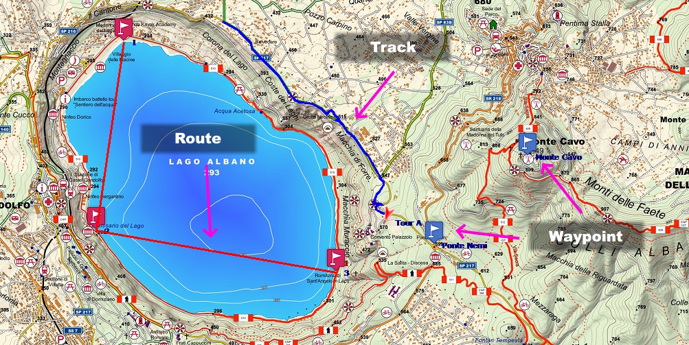
What Is a Waypoint?
A waypoint is a single geographic point identified by its GPS coordinates. It can represent any point of interest, such as a parking area, a spring, a mountain hut, a trail junction, a summit, or a scenic viewpoint. In addition to its coordinates, a waypoint can store a name, description, symbol and other useful information.
To learn more about organizing and using waypoints and points of interest, see the article Organizing waypoints and POIs.
Waypoints are used as reference points during GPS navigation and often serve as the building blocks from which routes are created. Unlike tracks, a waypoint does not describe a path; it simply identifies a precise location on the map.
What Is a Route?
A route is a planned itinerary consisting of an ordered sequence of waypoints. It originated in marine and aeronautical navigation, where each waypoint normally represents a position at which to change course or verify your location. In modern GPS devices for hiking and cycling, the concept has been extended: the device uses these points to guide the user along the route and may recalculate the path based on the available map data.
Routes are particularly useful when preparing a hike or a trip because they allow you to define the desired itinerary in advance. However, the actual path followed may vary depending on the available maps, the GPS navigator settings, and the type of device being used.
What Is a Track?
A track, also known as a GPS track, is a chronological sequence of points automatically recorded by a GPS receiver during movement. Each track point normally stores the position, elevation, date, and time of acquisition, making it possible to reconstruct the exact route that was actually traveled.
Unlike a route, a track does not require navigation calculations and does not depend on the maps installed on the device. For this reason, it is the most reliable format for sharing hiking, cycling, or off-road routes between different devices.
The Main Differences Between Waypoints, Routes, and Tracks
The fundamental difference lies in their purpose. A waypoint identifies a location, a route represents a planned itinerary, while a track documents the route actually traveled or an itinerary prepared as a sequence of closely spaced points. These three elements can coexist in the same GPX file and are often used together during outdoor activities.
A practical example makes the concept easier to understand. Before setting out, you can create a few waypoints representing the parking area, the mountain hut, and the summit. You then build a route connecting these points to plan your hike. During the hike, the GPS automatically records a track representing the route actually traveled, including any detours, stops, or navigation mistakes.
Waypoints, Routes, and Tracks Compared
| Element | What It Is | Main Purpose | Automatically Recorded |
|---|---|---|---|
| Waypoint | Geographic location with coordinates. | Store places of interest. | No. |
| Route | Ordered sequence of waypoints. | Plan an itinerary. | No. |
| Track | Sequence of recorded GPS points. | Document the route actually traveled. | Yes. |
In summary, a waypoint identifies a location, a route describes a planned itinerary, and a track represents the route actually recorded by the GPS. Understanding this distinction is essential for using GPX files correctly and taking full advantage of all the features offered by OkMap.
Waypoints, Routes, and Tracks in GPX Files
The GPX (GPS Exchange Format) was specifically designed to store waypoints, routes, and tracks within the same file. This makes it easy to exchange GPS data between software applications and devices from different manufacturers while keeping the various types of information separate.
The coordinates stored in GPX files are normally expressed in the WGS84 geographic coordinate system. To learn more about this topic, you can read the article on GPS coordinates.
In OkMap, each element is managed independently. You can create, edit, import, and export waypoints, routes, and tracks, convert them from one type to another when appropriate, analyze recorded tracks, and plan new itineraries using offline maps, elevation data, and a wide range of editing tools. To learn more about route analysis, you can also read the article GPX Track Analysis and Management.
When to Use Waypoints, Routes, and Tracks
The choice depends on the activity you want to perform. Waypoints are ideal for storing permanent points of interest, routes are best suited for planning an itinerary before departure, while tracks are the preferred solution for recording or sharing the actual path traveled without relying on the navigation engine of the GPS device.
In most outdoor activities, all three elements are used together: waypoints identify important locations, the route helps with planning, and the track accurately documents the completed hike, allowing you to analyze distance, time, elevation, and other statistics afterward.
If you are navigating at sea or in the air, a route represents the sequence of waypoints to be reached. In hiking, however, when you want to share an itinerary without depending on GPS route recalculation, a track is generally the preferred choice.