Clear and up-to-date definitions of the main terms used in
digital cartography, GPS systems, GIS, georeferencing,
digital elevation models and file formats.
How to use the glossary
This glossary is organized in alphabetical order.
To quickly find a definition, you can use the browser's
search function (Ctrl+F) or select a letter
from the alphabetical index.
Each entry includes a concise definition, additional information when
available, and, where applicable, details about its use in OkMap.
Definition. Three-dimensional representation of
the terrain in which the surface is modeled according to the
available elevation data, allowing the map to be displayed with
terrain features such as hills, valleys, and other landforms.
Further information. Three-dimensional
visualization uses terrain elevation data to construct the surface
on which the map is displayed. This makes it possible to observe
the terrain from different angles and to perceive its morphology
more easily. The quality of the representation depends on the
resolution and quality of the elevation data used.
Do not confuse with. A 3D map is a visualization
method for cartographic and elevation data and does not modify the
original map data or digital terrain model.
In OkMap. OkMap allows raster maps to be displayed
in 3D using the available elevation data. Web maps can also be
displayed in 3D, limited to the portion of the territory currently
visible in the map window.
Definition. Degree of closeness between a measured
position and its actual position. The higher the accuracy, the lower
the measurement error.
Further information. The accuracy of a GPS position
depends on many factors, including receiver quality, the geometry of
visible satellites, environmental conditions, and any errors introduced
by the atmosphere or signal reflections. Under normal conditions, a
civilian GPS receiver provides accuracy on the order of a few meters.
Example.
A GPS receiver remaining stationary at the same location may provide, over a few
minutes, positions distributed within an area of approximately 7-10 meters. Although
the individual measurements may be quite scattered, their average position is
generally close to the actual position. In this case, accuracy may be good,
while precision is limited.
Do not confuse with. Accuracy indicates how close a
measurement is to the actual value and should not be confused with
precision, which instead describes the repeatability of measurements.
In OkMap. Accuracy, when available, is obtained from
the GPS data source and can be used to assess the reliability of the
recorded position.
Definition. Geometric transformation that allows
the position, orientation, scale, and deformation of a surface to
be modified while preserving straight lines and parallelism.
Overview. In a two-dimensional affine transformation,
each transformed coordinate depends linearly on the two original
coordinates and on a translation term. The transformation can
therefore include translation, rotation, scale variation in the two
directions, and shear deformation. Unlike a similarity transformation,
it does not necessarily preserve angles and length ratios.
Not to be confused with. An affine transformation
is more general than a similarity transformation. The latter uses
a single uniform scale and preserves angles, while an affine
transformation can introduce different distortions in different
directions.
In OkMap. OkMap uses the affine transformation in
georeferencing procedures with three or more control points. When
more than three points are used, the transformation coefficients
are determined by considering the different control points and
averaging the resulting coefficients.
Definition. Vertical distance of a point relative
to a reference surface, generally mean sea level or a geodetic
ellipsoid.
Further information. Altitude can be expressed
relative to the geoid (orthometric height) or relative to the
ellipsoid (ellipsoidal height). GPS data normally provide
ellipsoidal height, while many topographic maps show elevations
referenced to mean sea level.
In OkMap. OkMap displays and manages the altitude
provided by the source of the data being used, such as a GPS
receiver, a GPX file, or a Digital Elevation Model (DEM).
Definition. Text file format used to represent
Digital Elevation Models (DEM) using a regular grid of elevation
values.
Further information. In addition to elevation values,
the file contains a header with the information required to
georeference the grid, such as the number of rows and columns,
cell size, and the coordinates of the reference corner. It is a
simple format, widely supported by GIS software and particularly
suitable for data exchange.
Do not confuse with. ASCII Grid is a format for
storing elevation data, not a Digital Elevation Model itself.
The same DEM can also be distributed in other formats, such as
HGT or GeoTIFF.
In OkMap. OkMap supports reading Digital Elevation
Models in ASCII Grid format. The data is used in elevation analyses
and can be used as a source for terrain elevation, even when other
models are available for the same area.
Definition. Horizontal angle measured clockwise
from a reference direction, used to determine the direction of
a point or a movement.
Further information. In cartography and GPS systems,
the reference direction is normally geographic North, but in other
contexts magnetic North, grid North, or other conventional directions
may be used. Azimuth is generally expressed in degrees, with values
ranging from 0° to 360°.
Do not confuse with. Azimuth does not necessarily
coincide with bearing, which may be expressed according to different
conventions depending on the context of use.
In OkMap. Azimuth is used in various analysis and
navigation functions, for example to determine the direction between
two points or along a GPS track.
Definition. Horizontal angle that identifies
the opposite direction from a given azimuth.
More information. The back azimuth is obtained
by adding 180° to the azimuth when it is less than 180°,
or subtracting 180° when it is greater than 180°. The result
is therefore always expressed as a value between 0° and 360°.
Do not confuse with. The back azimuth does not indicate
a new independent direction, but the opposite direction
from the one indicated by the reference azimuth.
In OkMap. The back azimuth is used
in various analysis and navigation functions, for example to
determine the opposite direction between two points.
Definition. Direction towards a destination,
generally expressed as an angle relative to a reference
direction.
Further information. In GPS systems, bearing normally
indicates the direction from the current position towards a destination,
such as a waypoint or a point along a route. During navigation, the
value continuously changes according to the user's position and
the destination to be reached.
Do not confuse with. Bearing indicates the direction
towards a destination and should not be confused with azimuth,
course, or heading, which describe different concepts.
In OkMap. Bearing is used in navigation functions
to guide the user towards waypoints, routes, or other
points of interest.
Definition. Coordinate representation system
used in the United Kingdom, based on a national metric
grid.
Further information. The British National Grid (BNG)
is derived from the EPSG:27700 coordinate reference system,
"OSGB36 / British National Grid".
Coordinates are expressed in meters and identified by a
pair of letters followed by numerical values that determine the
position within the national grid.
Do not confuse with. BNG represents a coordinate
representation system and is derived from a specific
coordinate reference system (CRS), with which it should not be confused.
In OkMap. The British National Grid is one of the
coordinate representation systems available in the coordinate
control. Conversions to and from other systems are performed
automatically.
Definition. A coordinate system that identifies
the position of a point using values referenced to orthogonal
axes.
Further information. Cartesian coordinates can
be represented by a pair of coordinates (X, Y) in the
two-dimensional (2D) case, or by a set of three coordinates
(X, Y, Z) in the three-dimensional (3D) case. They constitute a
general mathematical model used in many scientific and technical
fields. In cartography, metric coordinates represent a particular
application of two-dimensional Cartesian coordinates and are
normally expressed as (East, North). In geodesy, geocentric ECEF
coordinates instead represent a three-dimensional Cartesian
system.
Not to be confused with. Cartesian coordinates
represent a general mathematical concept and should not be
confused with metric coordinates, which are a particular
application of Cartesian coordinates in cartography.
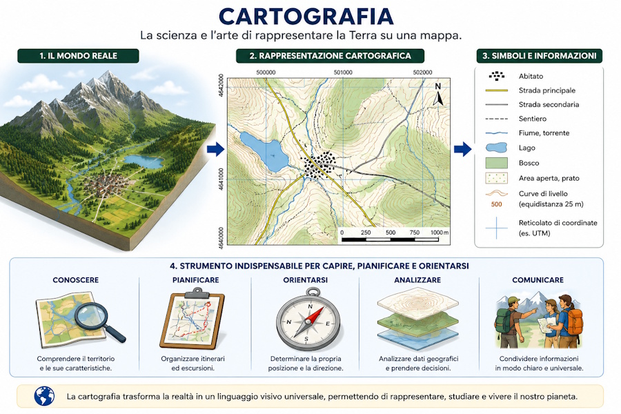
Definition. The discipline concerned with the
representation of the Earth's surface using geographic maps.
Cartography transforms the reality of the territory into a graphic
representation, using symbols, colors, contour lines and coordinates
to describe its characteristics.
Further information. Cartography includes the
creation, representation, updating and use of geographic maps.
Today, traditional paper maps are complemented by digital maps
used in GIS, navigation software, georeferencing applications
and GPS systems.
In OkMap. OkMap is digital mapping software
that allows users to display, georeference, analyze and use
raster and vector maps together with GPS data.
Definition. Instrument used to determine
a direction by means of the Earth's magnetic field.
Further information. A compass consists of a
magnetic needle that naturally aligns itself with magnetic North.
In navigation and cartography, it is used to determine
directions. The difference between magnetic North and true North
is called magnetic declination. Some GPS receivers are equipped with
an electronic compass, which allows the direction to be determined
even when the device is stationary or moving at low speed.
Do not confuse with. A compass determines a
direction using the Earth's magnetic field, whereas a
GPS receiver determines position and can calculate the
navigation direction using signals received
from satellites.
In OkMap. OkMap can acquire data from an
electronic compass through the NMEA HDT, HDM, and HDG sentences,
using them in navigation and orientation functions.
Definition. A georeferencing format used by
CompeGPS Land software to associate a raster map with its
corresponding geographic coordinates.
Further information. The IMP file contains the
information required to georeference a raster map, allowing the
software to determine its position, orientation and scale.
The map image is stored in a separate file, which is referenced
by the IMP file.
Not to be confused with. The CompeGPS (.imp)
file does not contain the raster map, but only its
georeferencing information. It should not be confused with the
CompeGPS TwoNav (.rmap) format, which directly incorporates the
georeferenced map.
In OkMap. OkMap supports reading and writing
the CompeGPS (.imp) format. During export, the IMP file is
generated together with the associated raster image, producing
a georeferenced map compatible with CompeGPS Land software.
Definition. A tiled raster format used by
CompeGPS Land software and TwoNav devices to store and display
georeferenced raster maps.
Further information. The RMAP format divides
the map into tiles, allowing efficient management of raster maps
even when they are very large. This organization means that only
the portions of the map required for display are loaded,
improving performance during panning and zooming. The format is
widely used for hiking, cycling and outdoor navigation.
Not to be confused with. The CompeGPS TwoNav
(.rmap) format should not be confused with RMaps SQLite
(.sqlitedb), which uses an SQLite database to store map tiles,
nor with the CompeGPS (.imp) file, which instead contains the
georeferencing information for a raster map.
In OkMap. OkMap supports reading and writing
the CompeGPS TwoNav (.rmap) format, allowing users to import and
export georeferenced raster maps compatible with CompeGPS Land
software and TwoNav devices.
Definition. Lines connecting all points having
the same elevation relative to a reference surface, used to
represent terrain relief on topographic maps.
Further information. A set of contour lines
makes it possible to interpret the shape of the terrain,
highlighting hills, valleys, slopes and plains. Closely spaced
contour lines indicate steep slopes, while widely spaced lines
correspond to gentler slopes. The contour interval, that is,
the constant elevation difference between two consecutive
contour lines, depends on the scale and characteristics of the
map.
Not to be confused with. Contour lines
represent constant terrain elevations and do not coincide with
the elevation profile of a route, which instead describes the
variation in elevation along a specific track.
In OkMap. When a digital elevation model (DEM)
is available, OkMap automatically generates contour lines as
vector polylines. The user can set the desired contour interval,
and the software organizes the contours into separate vector
layers, one for each elevation value.
Definition. The process by which the coordinates
of a position are converted from one coordinate representation or
reference system to another, while preserving, as defined by the
transformation, the geographic position to which they refer.
Further information. The same position can be
represented using different coordinate systems, such as decimal
degrees, degrees-minutes-seconds, UTM, MGRS or ECEF. When the
coordinate reference system (CRS) does not change, switching
between different coordinate representations is a simple
conversion. When the CRS also changes, a coordinate
transformation is required, taking into account the reference
systems involved and, when necessary, the corresponding datum.
Not to be confused with. Changing the way
coordinates are displayed does not necessarily mean performing
a geodetic transformation. Conversion between different
coordinate representations can be performed without changing the
CRS, whereas conversion between different CRSs requires a
specific transformation.
In OkMap. When the CRS does not change, the same
position can be displayed using different coordinate
representations simply by selecting the corresponding tab in the
coordinate panel. OkMap also provides specific functions for
explicitly converting coordinates between different CRSs, both
for a single position and for multiple coordinates contained in
a file. In many cases, conversions are performed automatically
by the software: for example, GPX data normally referenced to
WGS84 can be correctly displayed on a map based on a different
CRS without the user having to perform the transformation
manually.
Definition. Set of rules used to represent the
position of a point using one or more numerical values called
coordinates.
Details. There are many coordinate systems, each
designed for specific purposes. Common examples include geographic
coordinates (latitude and longitude), planar Cartesian coordinates
(such as UTM) and three-dimensional Cartesian coordinates (ECEF).
The same point on the Earth's surface can be represented by
different coordinates depending on the system used.
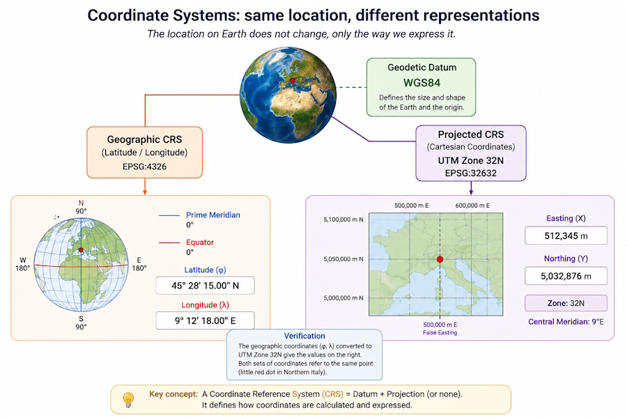
The same location on Earth can be expressed using different
coordinate systems, such as geographic or projected coordinates.
Do not confuse with. A coordinate system should
not be confused with a coordinate reference system (CRS). The
coordinate system defines how a position is expressed numerically,
whereas the reference system also provides the geodetic information
required to correctly interpret those coordinates.
In OkMap. OkMap supports numerous coordinate
systems and allows coordinates to be displayed, entered and
exported in the desired format, automatically performing conversions
between the supported systems.
Definition. Direction of movement relative to
true north, expressed as an angle between 0° and 360°.
Further information. Course represents the
direction of the trajectory actually followed over the ground
(ground track). It may differ from heading when the vehicle is
subject to wind, currents or drift, as occurs, for example, in
air and maritime navigation.
Not to be confused with. Course represents the
actual direction of movement, while heading indicates the
direction in which the vehicle is oriented. Bearing, on the
other hand, indicates the direction to follow to reach a
destination.
In OkMap. When available, OkMap uses the course
provided by the GPS receiver to represent the direction of
movement during navigation and track recording.
Definition. A set of rules that allows the
coordinates associated with points on the Earth's surface to be
interpreted correctly.
Further information. A coordinate reference
system (CRS) can be identified, for example, by an EPSG code,
such as EPSG:4326 (WGS84) or
EPSG:32632 (WGS84 / UTM zone 32N). The meaning
of coordinates always depends on the CRS being used, which
determines the datum, coordinate system, map projection (when
applicable) and the other parameters required to interpret them
correctly.
Not to be confused with. A CRS is not the same
as a datum or a map projection: both are fundamental components
of a CRS, together with the coordinate system and the other
parameters required to interpret coordinates correctly.
In OkMap. Each map is associated with a CRS,
which is used to display coordinates correctly and automatically
perform conversions between different reference systems and
coordinate systems.
Definition. A text file format used to store
tabular data as values separated by a delimiter character,
generally a comma or semicolon.
Further information. Each line of the file
represents a record, while fields are separated by a delimiter.
The first line normally contains the column names, which describe
the meaning of the data in the following rows. Thanks to its
simplicity, the CSV format is widely supported by spreadsheets,
databases, GIS software and GPS applications for exchanging
tabular and geographic data.
Not to be confused with. A CSV file contains
only data organized in tabular form and does not define the
structure of geographic data or the way they are represented
cartographically, as is the case with formats such as GPX, KML
or GeoJSON.
In OkMap. OkMap supports the import and export
of GPS data in CSV format using GPSBabel. During export,
separate files are generated for waypoints, tracks and routes.
In addition, all tables displayed in the application can be
exported in CSV format directly from the context menu, making it
easier to analyze and process data with spreadsheets and other
external tools.
Definition. Geodetic reference system that
defines how geographic coordinates are associated with points
on the Earth's surface.
Further information. A datum consists of a
reference ellipsoid and the parameters that define its shape,
dimensions, position, and orientation with respect to the Earth.
The meaning of geographic coordinates always depends on the datum
used. A coordinate reference system (CRS) always includes
a datum.
Not to be confused with. A datum should not be
confused with a coordinate reference system (CRS), which also
includes the map projection and its associated parameters.
In OkMap. OkMap automatically performs
coordinate transformations between different datums and
coordinate reference systems, using the corresponding
transformation parameters.
Definition. Coordinate representation system in
which latitude and longitude are expressed in decimal degrees.
Details. In decimal degrees, the fractional part
of the degree is represented as a decimal number, for example
41.89025° N, 12.49235° E. This is the representation most commonly
used in cartographic software, online mapping services and GPS
systems because it simplifies calculations and conversions.
Example.
Colosseum (Rome)
Latitude: 41.89025° N
Longitude: 12.49235° E
Do not confuse with. Decimal degrees represent
the same geographic position as DMM (degrees and decimal minutes)
and DMS (degrees, minutes and seconds). Only the format used to
express the coordinates changes.
In OkMap. OkMap allows coordinates to be
displayed, entered and automatically converted into decimal
degrees and the other supported representation systems.
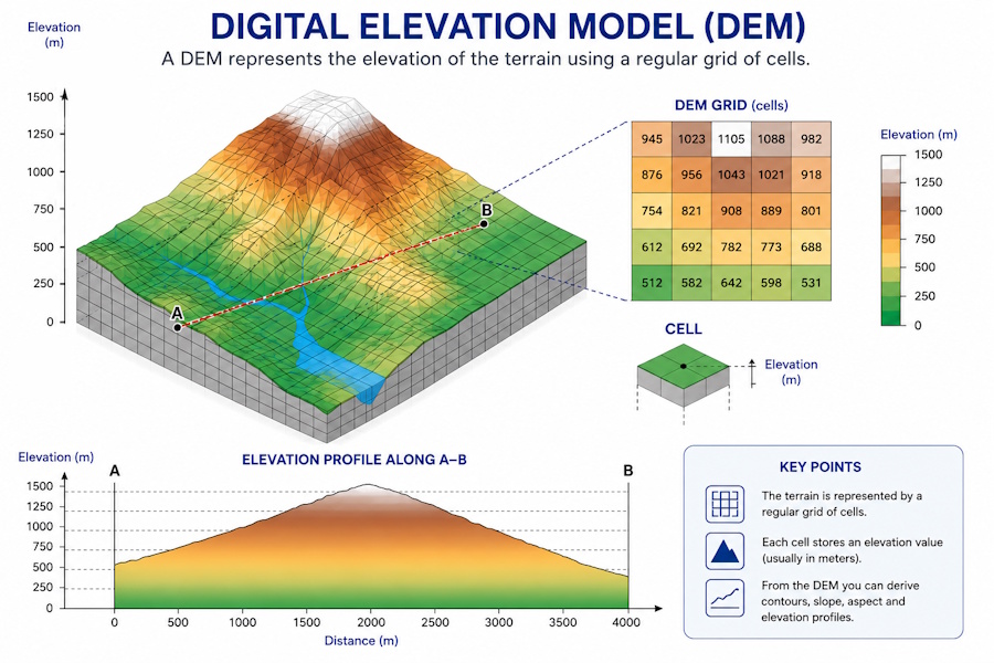
Definition. Digital representation of the
morphology of the terrain using a set of points associated with
elevation values.
Further information. Digital terrain models are
generally organized as a regular grid in which each cell contains
the elevation of the terrain at a given location. The distance
between cells determines the resolution of the model and therefore
the level of detail with which the terrain is represented. Digital
terrain models are used in numerous applications, including
elevation analysis, slope calculation, profile generation, and
visibility analysis. They can be distributed in various formats,
including HGT, ASCII Grid, and GeoTIFF. The term DEM can be used
generically to indicate a digital elevation model; in some contexts,
however, it is used specifically to indicate a model of the terrain.
A digital terrain model represents terrain elevation using a
grid of cells and makes it possible to derive information such
as elevation profiles, contour lines, and slopes.
Do not confuse with. A digital terrain model
represents the morphology of the ground using numerical elevation
values and should not be confused with a topographic map or satellite
image, which provide a visual representation of the territory. A DSM
instead represents the surface including features located above the
ground, whereas a DTM is generally intended to represent the terrain
without such features.
In OkMap. OkMap uses digital terrain models to
calculate elevation profiles, track statistics, slopes, three-dimensional
visualizations, and visibility analyses, and to automatically assign
terrain elevation to waypoints and tracks when it is not available.
In Preferences, under the DEM section, two folders can be
specified: one for SRTM files downloaded through OkMap and one for
GeoTIFF and ASCII Grid files manually provided by the user.
Downloaded SRTM files remain available in their respective folder
for subsequent use unless they are deleted. GeoTIFF and ASCII Grid
files present in the configured folder are read and indexed when
OkMap starts and whenever the corresponding setting in Preferences
is changed. The different elevation sources are then used
automatically according to the priority order set by the user.
SRTM data are read and interpolated directly by OkMap, while GeoTIFF
and ASCII Grid data are handled through GDAL.
Definition. Format for representing geographic
coordinates in which degrees are expressed as an integer and
minutes also include the decimal fraction.
Further information. In DMM format, latitude and
longitude are represented using degrees (°) and minutes ('),
while seconds are expressed as a decimal fraction of the minutes.
For example, the coordinate 45° 30.500' represents 45 degrees
and 30.500 minutes. This format is widely used in GPS receivers
and navigation systems.
Example.
Colosseum (Rome)
Latitude: 41° 53.415' N
Longitude: 12° 29.541' E
Not to be confused with. DMM format should not
be confused with DMS (Degrees Minutes Seconds), in which minutes
and seconds are expressed separately, nor with decimal degrees
(Deg), which represent geographic coordinates using a single
decimal value expressed in degrees.
In OkMap. OkMap supports the DMM format for
displaying and entering geographic coordinates, allowing
automatic conversion to the other available formats.
Definition. Format for representing geographic
coordinates in which degrees, minutes, and seconds are
expressed separately.
Further information. In DMS format, latitude and
longitude are represented using degrees (°), minutes ('), and
seconds ("). For example, the coordinate 45° 30' 30.5" represents
45 degrees, 30 minutes, and 30.5 seconds. It is one of the
traditional formats most widely used in cartography and navigation.
Example.
Colosseum (Rome)
Latitude: 41° 53' 24.9" N
Longitude: 12° 29' 32.46" E
Not to be confused with. DMS format should not
be confused with DMM (Degrees Decimal Minutes), in which the
fractional part of the coordinate is expressed as decimal minutes,
nor with decimal degrees (Deg), which represent geographic
coordinates using a single decimal value expressed in degrees.
In OkMap. OkMap supports the DMS format for
displaying and entering geographic coordinates, allowing
automatic conversion to the other available formats.
Definition. Indicator of the quality of the
geometry of the satellites used to determine a position
using GNSS.
Further information. The DOP value depends on
the relative geometry between the receiver and the visible
satellites. Low values indicate a favorable configuration and,
in general, allow greater positional accuracy, while high values
indicate less favorable geometry. There are several types of
DOP, including HDOP (Horizontal DOP), VDOP (Vertical
DOP), and PDOP (Position DOP).
Not to be confused with. DOP does not directly
represent positional accuracy, but rather an indicator of the
quality of the satellite geometry used to determine the position.
In OkMap. When available, OkMap displays the
DOP values provided by the GPS receiver, allowing the quality
of the satellite geometry to be assessed during surveying or
navigation.
Definition. Digital model representing the
elevation of the Earth's surface, including not only the
terrain but also features present on its surface, such as
vegetation, buildings, and other structures.
Further information. A DSM describes the
observable surface of the territory and not necessarily the bare
ground. Unlike a digital terrain model (DEM), which may represent
the elevation of the terrain without overlying features, a DSM
can therefore contain the elevations of trees, buildings, and
other structures. DSMs are used, among other things, in
visibility analysis, three-dimensional modeling, and the study
of terrain morphology.
Not to be confused with. DSM and DEM are not
necessarily synonyms. A DSM represents the surface including
features located above the ground, while a terrain model may
refer to the underlying ground surface. Terminology may
nevertheless vary depending on the data source.
In OkMap. OkMap can use elevation models
for processing that requires information about terrain elevation.
The software does not automatically distinguish a DSM from a
DEM based solely on elevation values: the meaning of the elevations
depends on the model and the data provided.
Definition. Digital model representing the
elevation of the terrain, aiming to describe the ground surface
independently of features located above it, such as buildings
and vegetation.
Further information. A DTM describes terrain
morphology and can be used to derive information such as slope,
aspect, elevation profiles, and visibility analysis. Unlike a
model representing the observable surface, a DTM aims to
represent the underlying terrain, excluding artificial and
natural features rising above the ground.
Not to be confused with. DTM and DSM describe
different surfaces: a DTM represents the terrain, while a DSM
may include buildings, vegetation, and other structures present
on the surface. The term DEM, on the other hand, is used
inconsistently and may refer generically to a digital elevation
model, or specifically to a terrain model similar to a DTM.
In OkMap. OkMap uses elevation models for
various processing tasks that require information about
terrain elevation. The software uses the elevation values
provided by the data without automatically classifying the model
as a DTM or DSM; the meaning of the elevations therefore depends
on the nature and characteristics of the data used.
Definition. Three-dimensional Cartesian coordinate
system with its origin at the Earth's center of mass and its axes
fixed to the Earth's rotation.
Details. In the ECEF system, each point is
represented by three Cartesian coordinates (X, Y, Z),
generally expressed in meters. The Z axis coincides with the Earth's
rotation axis, while the X and Y axes lie in the equatorial plane.
ECEF coordinates are widely used in GNSS systems and constitute an
intermediate system used in transformations between geographic,
metric and different reference system coordinates.
Example.
Colosseum (Rome) X = 4642569.2 m Y = 1028581.9 m Z = 4236536.4 m
Not to be confused with. ECEF coordinates are
three-dimensional Cartesian coordinates and should not be confused
with geographic coordinates or with metric coordinates
used in coordinate representation systems.
In OkMap. OkMap allows you to display, enter
and convert coordinates in the ECEF system. Internally, it also uses
ECEF coordinates in geodetic transformations between
different datums.
Definition. Raster format based on wavelet compression,
designed to store large georeferenced images while maintaining high
visual quality and requiring relatively little storage space.
Details. The ECW format uses a compression technique
that allows even large maps and orthophotos to be displayed quickly
without having to load the entire image into memory. For this reason,
it has been widely used for the distribution of raster cartography
and high-resolution aerial photographs.
Not to be confused with. The ECW format is optimized
for storing and displaying large raster images and should not be
confused with formats such as GeoTIFF, which prioritize
interoperability and can use different compression methods.
In OkMap. OkMap supports reading ECW files,
allowing you to use large georeferenced raster maps and orthophotos.
Writing this format is not supported.
Definition. European system designed to improve
the accuracy and reliability of satellite navigation systems,
based on the transmission of corrections and integrity information
through geostationary satellites.
Details. EGNOS is the European SBAS
(Satellite Based Augmentation System) and improves the performance
of GNSS systems within its coverage area. The transmitted information
makes it possible to correct some of the errors affecting positioning
and to provide information about the reliability of navigation data.
EGNOS is mainly used for applications requiring greater positioning
accuracy and reliability.
Not to be confused with. EGNOS is not an independent
GNSS such as GPS or Galileo, but an augmentation system that uses
information from GNSS systems to improve their performance.
In OkMap. OkMap can use coordinates determined by
the GNSS device, benefiting from any augmentation systems supported
by the receiver. The operation and availability of EGNOS depend on
the GNSS receiver and its configuration.
Definition. Mathematical surface that approximates
the shape of the Earth and is used as a reference for defining
geodetic systems.
Details. An ellipsoid is defined primarily by the
values of the semi-major axis and semi-minor axis or, alternatively,
by the semi-major axis and flattening, from which its shape and
dimensions are derived. Since the Earth is not a perfect sphere,
the ellipsoid provides a mathematical approximation that is
sufficiently accurate for most geodetic and cartographic
applications. A datum uses a reference ellipsoid and defines its
position and orientation relative to the Earth. Different datums
may use the same ellipsoid while differing in position and
orientation relative to the Earth.
Not to be confused with. The ellipsoid is a
mathematical model of the Earth and should not be confused with
the geoid, which represents an equipotential surface of the
Earth's gravitational field.
In OkMap. OkMap uses the ellipsoids associated
with different datums and coordinate reference systems to perform
coordinate transformations and conversions between different
systems.
Definition. Height of a point measured along the
normal to the reference ellipsoid, relative to the surface
of the ellipsoid itself.
Further information. Ellipsoidal height indicates the
distance between a point on the Earth's surface and the reference
ellipsoid used by the geodetic system. It is commonly indicated by
the letter h and represents the type of height normally
associated with coordinates obtained from GNSS systems.
It does not necessarily coincide with height above mean sea level.
Do not confuse with. Ellipsoidal height is referenced
to the ellipsoid, whereas orthometric height is referenced
approximately to the geoid and represents elevation above
mean sea level. The difference between the two is related to
geoid undulation.
In OkMap. Ellipsoidal height is supported in the
internal coordinate structures and is used in transformations between
geographic and ECEF coordinates, which form the basis of datum
transformations. However, it is not normally displayed or used in
the main cartographic processing performed by the software.
Definition. Coding standard that assigns unique
numerical identifiers to coordinate reference systems (CRS), datums,
ellipsoids, units of measurement and other geodetic entities.
Details. The acronym EPSG derives from
European Petroleum Survey Group, the organization that
developed the coding system now adopted as an international standard.
EPSG codes uniquely identify coordinate reference systems, datums,
ellipsoids, units of measurement and other geodetic entities,
ensuring interoperability between software, data and mapping services.
Not to be confused with. An EPSG code uniquely
identifies a geodetic entity, but does not describe its
characteristics, which are defined by the corresponding parameters.
In OkMap. OkMap uses EPSG codes to uniquely
identify coordinate reference systems and geodetic entities,
ensuring compatibility with international standards and with
other GIS and navigation software.
Definition. Vector format developed by ESRI for
storing geographic features such as points, lines and polygons,
together with their associated descriptive attributes.
Details. A Shapefile consists of a set of files
that share the same name but have different extensions. The main
ones include .shp, which contains the geometries,
.shx, which stores the spatial index,
.dbf, which contains the attributes associated
with the geographic features, and .prj, which
describes the coordinate reference system. Thanks to its simplicity
and widespread support by GIS software, the Shapefile is still
one of the most widely used vector formats today.
Not to be confused with. A Shapefile does not
consist of a single file, but of a set of complementary files.
The absence of one or more files may limit the available information
or prevent the data from being used correctly.
In OkMap. OkMap supports reading and writing
Shapefiles. During export, the files .shp,
.shx, .dbf and .prj
are generated. During import, a vector layer is created for each
Shapefile and the user can define its main display characteristics,
such as color, line width, fill and labeling.
FIT (Flexible and Interoperable Data Transfer) (.fit)
Category: GPS data format
Definition. Binary format designed to store
data from GPS and fitness devices, such as tracks, waypoints,
sports activities, and sensor data.
Details. The FIT format was developed by
Garmin to replace less efficient text-based formats such as
GPX for recording sports activities. Thanks to its binary structure,
it offers reduced file sizes, high efficiency, and the ability
to store, in addition to geographic position, numerous data such as
heart rate, cadence, power, temperature, and other information
from sensors.
Not to be confused with. The FIT format is
primarily intended for recording sports activities and may
contain information that has no direct equivalent in the
GPX format, which is instead oriented toward exchanging GPS data
between different applications.
In OkMap. OkMap uses GPSBabel to read and
write the FIT format, allowing the import and export of
GPS data supported by this format.
Definition. Format developed by Garmin that
allows georeferenced raster maps to be displayed on compatible
GPS devices, using KMZ files containing images and geographic
information.
Details. A Garmin Custom Map consists of one or
more georeferenced raster images, divided into tiles and stored
in a KMZ file. On the GPS device, the map is overlaid on the
basemap, allowing custom maps to be displayed during navigation.
In OkMap. OkMap can create Garmin Custom Maps
from georeferenced raster maps, automatically dividing the image
into the tiles required by the format and checking compliance
with the relevant limits. When necessary, it proposes resizing
the image to ensure compatibility with Garmin devices.
Definition. Proprietary vector cartographic
format used by Garmin devices to store road, topographic and
thematic maps.
Details. The IMG format contains vector data
optimized for display and navigation on Garmin devices. It can
include information such as roads, trails, contour lines, points
of interest and other cartographic elements.
In OkMap. OkMap does not support the Garmin IMG
format. OkMap can instead create Garmin Custom Maps and export
waypoints, tracks and routes in formats supported by Garmin
devices.
Definition. Format used by Garmin devices to
store collections of points of interest (POIs), such as service
areas, shelters, parking areas, speed cameras and other useful
locations during navigation.
Details. Garmin POIs are organized into
categories and can include, in addition to geographic coordinates,
descriptive information, custom icons and, on compatible devices,
proximity alerts.
In OkMap. OkMap can import and export Garmin POIs,
automatically converting points of interest to waypoints and
vice versa.
Definition. Coordinate reference system
historically used in Italy, based on the Roma40 datum and the
conformal Gauss projection, with the territory divided into the
two West and East zones.
Details. The Gauss-Boaga system was the official
Italian cartographic reference for many years and is still present
in numerous technical maps and cartographic archives. There are
several historical variants associated with the Roma40 datum,
differing, among other things, in the prime meridian adopted
(Greenwich or Monte Mario). Coordinates are expressed in metres
using metric coordinates (East, North) and include a different
false origin for each zone, avoiding negative values.
In OkMap. OkMap supports the Gauss-Boaga system
both for displaying coordinates and for georeferencing maps and
transforming coordinates to other coordinate reference systems.
Definition. Ground control point that relates a
point in an image, expressed in pixels, to the corresponding
real-world position, expressed using geographic or cartographic
coordinates. GCPs are used to georeference raster images.
Details. Each GCP consists of a pair of
coordinates: one identifies the position in the raster image,
while the other identifies the corresponding real-world position,
expressed in the selected coordinate system. Using a sufficient
number of GCPs distributed across the map, it is possible to
calculate the transformation required to georeference the image
with high accuracy.
In OkMap. During georeferencing, OkMap allows
you to define, edit and manage GCPs directly on the map,
displaying both their pixel position and the corresponding
geographic or projected coordinates. For each control point,
OkMap also calculates the georeferencing error. If the error
exceeds the threshold set in Preferences - Georeferencing,
the point is highlighted in the corresponding information box
and marked with a specific icon. The map information also
reports the error of each control point, together with the
minimum and maximum values and the RMS error,
allowing you to assess the overall quality of the calibration.
Definition. Process that determines the geographic
coordinates of a location from an address, place name or another
descriptive reference.
Details. Geocoding uses online mapping services
to search for a location and return its coordinates. The accuracy
of the result depends on the quality of the available data and
the specificity of the information provided by the user.
Do not confuse with. Geocoding determines the
coordinates of a location from a textual description. The reverse
process, which retrieves an address from coordinates, is called
reverse geocoding.
In OkMap. From the context menu of the coordinate
panel, it is possible to call the geocoding function, specify an
address or place and automatically obtain the corresponding
coordinates. The coordinates are then displayed in all coordinate
representation systems supported by the software.
Definition. A coordinate representation system
that identifies the position of a point on the Earth's surface
using latitude and longitude.
The position of a point on Earth can be identified using
latitude and longitude, referenced to the Equator and the
Greenwich meridian.
Further information. Geographic coordinates are
expressed as a pair of angular values (latitude and longitude)
and can be represented in decimal degrees (Deg), degrees and
minutes (DMM), degrees, minutes and seconds (DMS), or radians
(Rad). Their meaning depends on the geodetic datum used.
Not to be confused with. Geographic coordinates
are expressed as angular values and should not be confused with
metric coordinates, which are expressed in metres.
In OkMap. OkMap allows geographic coordinates
to be displayed and automatically converted between the Deg,
DMM, DMS and Rad formats.
Definition. A scaled representation of the Earth's
surface, or part of it, created according to cartographic
principles.
Further information. Geographic maps can
represent territories with different levels of detail and
purposes. There are many types of maps, including topographic,
road, nautical, aeronautical, geological and thematic maps,
each designed for specific consultation, analysis or
navigation needs.
Not to be confused with. Geographic map is a
general term that includes different types of maps, including
topographic maps. It should not be confused with an orthophoto
or satellite image, which are photographic representations of
the Earth's surface.
In OkMap. OkMap allows the use of numerous
types of geographic maps, both raster and vector, as well as
online mapping services.
Definition. Equipotential surface of the Earth's
gravity field that approximates mean sea level, ideally extended
beneath the continents. The geoid represents a natural reference
surface for measuring elevations.
Details. Unlike the ellipsoid, which is a regular
mathematical surface, the geoid has undulations caused by the
non-uniform distribution of Earth's masses. The height of the geoid
relative to the ellipsoid varies from one location to another and
is used to convert ellipsoidal heights into elevations.
Do not confuse with. The geoid does not coincide
with the ellipsoid: the former represents a physical surface related
to Earth's gravity field, while the latter is a mathematical surface
used as a model of the Earth.
In OkMap. OkMap uses the elevations provided by
the GPS or GNSS receiver. Alternatively, the user can replace them
with elevations obtained from locally available DEM data, which
can be downloaded automatically when they are not already present.
Definition. Open JSON-based format for the
representation and exchange of geographic vector data, such as
points, lines and polygons, together with their associated
attributes.
Details. GeoJSON is a widely used standard in
web applications and GIS systems because of its simplicity and
readability. In addition to geometries, it can contain descriptive
information associated with geographic objects.
In OkMap. OkMap does not support the GeoJSON
format for importing and exporting vector data. However, it is
possible to import and export waypoints, tracks and routes in
GeoJSON format.
Definition. PDF format that incorporates
georeferencing information, allowing geographic coordinates to
be associated with the cartographic content of the document.
Details. A GeoSpatial PDF retains all the
characteristics of a standard PDF document, but also includes
the information required to determine the geographic position of
each point on the map. It is widely used to distribute topographic
maps, orthophotos and other digital cartography, allowing them to
be viewed both with standard PDF readers and compatible GIS
software.
Do not confuse with. A GeoSpatial PDF is not
simply a standard PDF document: in addition to graphical content,
it contains georeferencing information that makes it possible to
determine the geographic coordinates of the map.
In OkMap. OkMap uses GDAL to read and write
GeoSpatial PDF files, allowing georeferenced maps to be imported
and exported while preserving the spatial information associated
with the document.
Definition. Geographic reference system that
identifies a position on the Earth's surface using a combination
of letters and numbers. It was developed to allow locations on
maps to be uniquely identified.
Details. The GeoRef system divides the Earth's
surface into hierarchical cells of progressively smaller size,
allowing a position to be represented with varying levels of
precision. Although it is less widely used today than other
coordinate systems, it continues to be used in some cartographic
and aeronautical fields.
Example.
Colosseum (Rome) NJ NM 2954 5342
In OkMap. OkMap supports the GeoRef system for
entering, displaying and converting coordinates, allowing
automatic conversion to and from the other supported coordinate
systems.
Definition. Process by which a digital image is
associated with a geographic or cartographic coordinate system,
making it possible to determine the real-world position of every
point on the image.
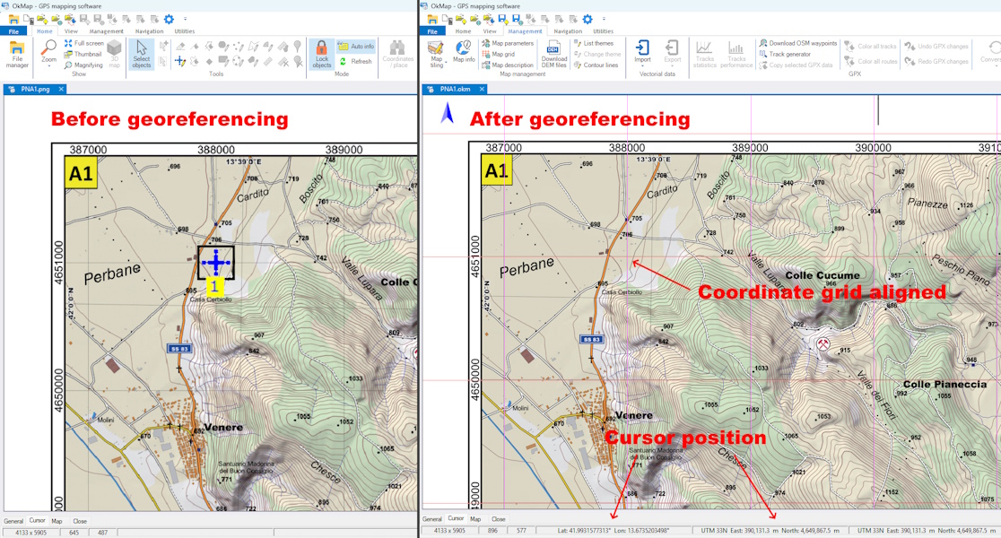
Example of raster map georeferencing: after the operation,
the coordinate grid is correctly aligned with the map.
Details. Georeferencing is performed by identifying
one or more control points (GCPs) on the map, whose position on the
image and corresponding real-world coordinates are both known.
Based on the GCPs and the selected transformation method, the
relationship between the raster image and the reference system is
calculated, allowing correct overlay with other maps and geographic
data.
In OkMap. Georeferencing is one of OkMap's main
features. The software supports several transformation methods,
allows coordinates to be used in numerous coordinate reference
systems and provides tools for verifying the correctness of
georeferencing by comparing it with other cartographic references.
Definition. Raster format based on TIFF that
incorporates georeferencing information directly into the file,
allowing each pixel to be associated with its corresponding
geographic or cartographic position without relying on external
files.
Details. In addition to the image, a GeoTIFF file
can contain information about the coordinate reference system (CRS),
the coordinates of the represented area and other cartographic
metadata. It is one of the most widely used formats for exchanging
georeferenced maps between GIS software and cartographic
applications.
In OkMap. OkMap supports the GeoTIFF format for
importing, exporting and georeferencing raster maps. GeoTIFF is
one of the software's main interchange formats and is also used
for managing elevation data.
Definition. Information system designed to
acquire, store, manage, analyze and represent geographic data
related to the Earth's surface. GIS systems allow cartographic
information and descriptive data to be integrated to support
analysis and planning activities.
Details. A GIS manages raster and vector data,
coordinate reference systems, spatial databases and numerous
geographic analysis functions. It is used in fields such as
territorial planning, environmental management, transportation,
civil protection and infrastructure management.
In OkMap. Although it is not a general-purpose
GIS, OkMap provides numerous features commonly found in GIS
systems, including raster map and vector data management,
georeferencing, support for coordinate reference systems and
integration with GPS data and web maps.
Definition. Generic term identifying the group
of global satellite navigation systems used to determine position,
velocity and time at any point on the Earth's surface.
Details. In addition to GPS, GNSS systems include
Galileo (European Union), GLONASS (Russia), BeiDou (China) and
other regional satellite systems. Modern receivers frequently use
signals from multiple constellations, improving the accuracy,
availability and reliability of positioning.
Do not confuse with. GNSS is the general term
encompassing all satellite navigation systems. GPS, on the other
hand, is the name of the system developed by the United States and
is one of the GNSS systems currently available.
In OkMap. OkMap uses data provided by GNSS
receivers regardless of the satellite constellation being used,
allowing waypoints, tracks and routes to be managed without
distinction between the different navigation systems.
Definition. Satellite navigation system developed
by the United States that allows position, velocity and time to be
determined at any point on the Earth's surface.
Details. The GPS system consists of a constellation
of satellites that continuously transmit signals to receivers on
the ground. Today, the term GPS is often used, even in common
language, to refer generically to satellite navigation systems,
although it actually represents only one of the available GNSS
systems.
Do not confuse with. GPS is a specific satellite
navigation system, while GNSS is the general term encompassing
GPS, Galileo, GLONASS, BeiDou and other similar systems.
In OkMap. OkMap acquires and manages position data
from GPS or GNSS receivers, enabling navigation, track recording
and waypoint and route management.
Definition. Set of formats used to store,
exchange, and share data from GPS receivers and navigation
software.
Details. GPS formats can store waypoints, tracks,
routes, position information, and other navigation data. Some are
open standards, such as GPX, while others are specific to particular
devices or applications. The choice of format affects compatibility
between software, GPS receivers, and mapping services.
In OkMap. OkMap uses GPX as the native format for
waypoints, tracks, and routes, while also supporting the import
and export of numerous other GPS formats.
Definition. Set of techniques and tools that allow
users to determine their position, follow a route and reach a
destination using data provided by a GPS or GNSS receiver.
Further information. GPS navigation is based on
the continuous acquisition of the current position and the
calculation of information such as direction, distance, speed,
estimated time of arrival and deviation from the planned route.
It can be used to follow a recorded track, reach a waypoint or
follow a planned route.
In OkMap. OkMap provides a comprehensive set of
GPS navigation tools, including position acquisition from
integrated GPS receivers or devices transmitting NMEA sentences,
navigation simulation, track recording, navigation to waypoints
and along routes, as well as position sharing with other local
or remote devices.
Definition. Open XML-based format for exchanging
GPS data between software and navigation devices. It can store
waypoints, routes and tracks together with their associated
descriptive information.
Details. A GPX file can contain zero or more
waypoints, routes and tracks, including them simultaneously. In
addition to geographic coordinates, it can store elevations, times,
names, descriptions and other information associated with waypoints,
routes and tracks, facilitating interoperability between software,
GPS devices and navigation services.
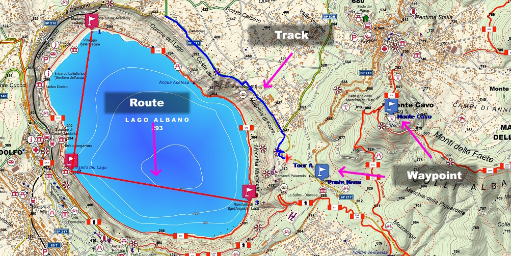
A GPX file can contain waypoints, routes and tracks, used
respectively to indicate points of interest, planned routes
and GPS tracks.
Do not confuse with. GPX is a file format, not a
type of data. Waypoints, routes and tracks are geographic objects
that can be stored in the same GPX file or in separate files.
In OkMap. GPX is the native format used by OkMap
for storing and exchanging waypoints, routes and tracks. In
addition to the elements defined by the GPX standard, OkMap can
use XML extensions of the format to store additional information,
while maintaining compatibility with applications that support
the standard. The same extensions are also shared with OkMap
Mobile, allowing proprietary information to be exchanged between
the two applications. The software can also convert waypoints,
routes and tracks into vector data and vice versa, facilitating
integration between GPS data and cartography.
Definition. Direction in which the longitudinal
axis of a vehicle is oriented, generally expressed as an angle
relative to North.
Further information. Heading describes the
orientation of the vehicle independently of its actual direction
of movement. In maritime navigation, for example, a vessel may
maintain a heading different from its course due to the effect
of wind or sea currents.
Not to be confused with. Heading indicates
the orientation of the vehicle, whereas course represents the
actual direction of movement relative to the ground. In the
presence of wind or currents, heading and course may differ.
In OkMap. OkMap uses heading information
transmitted by the GPS or GNSS receiver according to the
NMEA standard.
Definition. File format used to store Digital
Elevation Models (DEM), developed as part of NASA's Shuttle
Radar Topography Mission (SRTM).
Further information. Each HGT file contains
a regular grid of elevation values covering an area of one
degree by one degree of latitude and longitude. The data are
available at different resolutions (1 or 3 arc-seconds,
corresponding to approximately 30 m or 90 m at the equator)
and are widely used for terrain analysis, elevation profile
calculation and slope analysis.
In OkMap. OkMap uses HGT files to obtain
terrain elevations, also in combination with other supported
DEM formats, for numerous elevation-related operations. When
necessary, the software can automatically download missing
SRTM data for the area of interest.
Definition. Simulated three-dimensional
representation of terrain derived from a digital elevation
model, using virtual illumination of the surface from a
specified direction and angle.
Further information. Hillshade uses variations
in terrain elevation to simulate the effect of light and shadows,
making the morphology of the surface more apparent. Areas facing
the light source appear brighter, while areas facing away from it
appear darker. The result is particularly useful for visualizing
hills, valleys, ridges and other morphological features of the
terrain.
Not to be confused with. Hillshade does not
directly represent terrain elevations and is therefore not a
digital elevation model. It is a representation derived from
an elevation model and can be used as a map background or
overlay.
In OkMap. OkMap can generate a georeferenced
hillshade raster map from an SRTM DEM file. The processing is
performed using GDAL and the result can be used as a normal
georeferenced raster map. OkMap can also generate raster maps
with a color relief representation, assigning different
colors to different terrain elevations. The generated raster
maps can also be displayed in 3D.
Definition. Metric coordinate system used in
Ireland to identify the position of points throughout the
country.
Further information. The Irish Grid is based on a
conformal map projection and uses a metric grid divided into
squares identified by letters and coordinates expressed in
metres. It was for many years the official reference system
for Irish cartography.
Example.
Trinity College (Dublin) O 15940 34099
In OkMap. OkMap allows coordinates expressed
in the Irish Grid system to be displayed, entered and
automatically converted.
Definition. Raster map format used by some
Garmin devices to display georeferenced maps divided into
tiles.
Further information. The JNX format is designed
to handle large raster maps by dividing the image into tiles.
This organization allows the device to load only the portions
of the map needed for display, improving performance and
reducing memory usage.
Not to be confused with. The JNX format should
not be confused with Garmin Custom Maps based on KMZ. Both allow
georeferenced raster maps to be displayed on Garmin devices,
but they use different formats and management methods.
In OkMap. OkMap allows JNX version 3 and 4 files
to be created from georeferenced raster maps, preparing them
for display on compatible Garmin devices.
Definition. Raster format based on wavelet
compression, designed to store high-quality images while
reducing storage space compared with uncompressed raster
formats.
Further information. Unlike the traditional JPEG
format, JPEG2000 uses a wavelet compression technique that
provides better image quality at the same file size. It can use
both lossy and lossless compression and is widely used in
cartography, remote sensing and the storage of high-resolution
images. The format can also incorporate georeferencing
information.
Not to be confused with. JPEG2000 should not be
confused with the JPEG (.jpg) format, which differs both in its
compression algorithm and in the features it provides, including
support for lossless compression and georeferencing.
In OkMap. OkMap uses GDAL to read and write the
JPEG2000 format, allowing the import and export of georeferenced
raster maps.
Definition. Open XML-based format for the
representation and exchange of geographic data. Originally
developed for Keyhole Earth Viewer, it is now widely used
by Google Earth and numerous mapping software applications.
Details. A KML file can contain points,
lines, polygons, georeferenced images, descriptions, display
styles, and other elements organized in a hierarchical
structure. Thanks to its flexibility, it is one of the most
widely used formats for sharing geographic data.
Do not confuse it with. KML is an XML-based
format, while KMZ is its compressed version, generally
used to distribute geographic data and its associated
resources in a single file.
In OkMap. OkMap supports the import and
export of KML files for exchanging waypoints, routes,
tracks, and georeferenced raster maps. GPS data and maps
are handled separately, in accordance with the characteristics
of the format.
Definition. Compressed version of the KML
format, consisting of a ZIP archive with the .kmz
extension, containing a KML file and any associated resources,
such as images, icons, and other files used to represent
geographic data.
Details. Thanks to compression and the ability
to include all resources in a single file, KMZ is the format
most commonly used for exchanging geographic data intended
for Google Earth and other compatible software. By renaming
the file extension from .kmz to .zip,
its contents can be opened and the KML file and associated
resources accessed directly.
Do not confuse it with. KMZ is not a format
different from KML, but its compressed version. Both describe
the same types of geographic data.
In OkMap. OkMap supports the import and
export of KMZ files for exchanging waypoints, routes,
tracks, and georeferenced raster maps. The KMZ format is
also used to create maps in the Garmin Custom Map format.
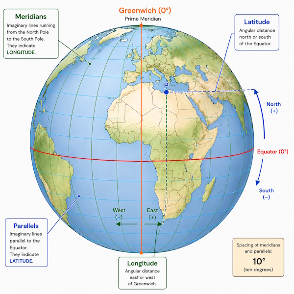
Definition. Geographic coordinate indicating the
position of a point relative to the Equator, expressed as an angle
between 0° and 90° toward the North or South.
Details. Latitude is measured along the meridians
and indicates the angular distance of a point from the Equator.
It can be expressed using the letters N (North) and S (South) or,
in some coordinate representation systems, by a positive or
negative value.
Example.
Colosseum (Rome) 41.89025° N
Do not confuse it with. Latitude indicates the
position relative to the Equator, while longitude indicates the
position relative to the prime meridian.
In OkMap. OkMap allows you to display, enter,
and automatically convert latitude using the different geographic
coordinate representation systems supported by the software.
Definition. Logical level used to organize and
represent cartographic information independently of the other
elements displayed on the map.
Details. A map is generally represented by
superimposing multiple layers, each containing a specific type of
information. The display order of the layers determines which
elements appear in the foreground and which remain in the
background.
Do not confuse it with. A layer does not
necessarily correspond to a file. A single file can contain
multiple layers and, conversely, a layer can consist of data
originating from different sources.
In OkMap. OkMap uses layers to organize map
rendering. The base level consists of the map itself, over which
grids, vector data, place names, photographs, waypoints, routes,
tracks, and other graphical elements used by the software are
progressively superimposed. Vector data can be displayed
independently of the type of map being used, enriching its
informational content.
Definition. Geographic coordinate indicating the
position of a point relative to the prime meridian, expressed as
an angle between 0° and 180° toward the East or West.
Details. Longitude is measured along the parallels
and indicates the angular distance of a point from the Greenwich
prime meridian. It can be expressed using the letters E (East) and
W (West) or, in some coordinate representation systems, by a
positive or negative value.
Example.
Colosseum (Rome) 12.49235° E
Do not confuse it with. Longitude indicates the
position relative to the prime meridian, while latitude indicates
the position relative to the Equator.
In OkMap. OkMap allows you to display, enter,
and automatically convert longitude using the different geographic
coordinate representation systems supported by the software.
Definition. Angle between true north and
magnetic north at a given point on the Earth's surface.
Further information. Magnetic declination varies
according to geographic location and changes slowly over time due
to variations in the Earth's magnetic field. Its value can be
eastward (positive) or westward (negative), according to the
convention used.
Example.
Colosseum (Rome)
At the Colosseum in Rome, magnetic declination is approximately
4° East (a value that varies over time). This means that
true north is approximately 4° east of
magnetic north. To align a compass with
geographic north as represented on maps, this difference must
therefore be taken into account (or the software can compensate
for it automatically when this information is available).
Magnetic declination is not the same throughout the world: in
Italy it is generally on the order of a few degrees, while in
other regions of the Earth it can exceed 20°.
Not to be confused with. Magnetic declination
represents the angular difference between true north and
magnetic north and should not be confused with magnetic
deviation, which is caused by magnetic fields generated by
a vehicle or other nearby metal objects.
In OkMap. When available, OkMap uses the
magnetic declination provided by the GPS receiver or electronic
compass to automatically convert directions between magnetic
north and true north.
Definition. Direction indicated by the needle of a
compass, corresponding to the Earth's magnetic north pole.
Further information. Magnetic north does not
coincide with geographic north (or true north), because the magnetic
north pole is located at a different position and changes slowly
over time. The angle between magnetic north and true north is
called magnetic declination.
Do not confuse with. Magnetic north should not be
confused with true north, which represents the direction of the
geographic North Pole.
In OkMap. OkMap can use information referenced to
magnetic north when received from external devices, for example
through NMEA sentences from an electronic compass.
Definition. Representation of the Earth's surface
or a portion of it, created according to a specific reference
system and scale, to allow the visualization and analysis of
geographic information.
Further information. A map can be created in
raster, vector, or web-based form. Each type has different
characteristics and uses, but all allow the representation of
territory and the information associated with it.
In OkMap. A map can consist of a raster map, one
or more web maps over which one or more georeferenced raster maps
can be overlaid, or a pure vector map defined by vector data and
its bounding box. In all of these cases, vector data can
be defined as an integral part of the map and saved together with
it. Waypoints, routes, tracks, place names, photographs, and other
data managed by the software are instead independent information
layers that can be overlaid on the map but are stored separately.
In the case of raster maps and web maps, vector data can also be
used to enrich the cartographic representation with additional
information.
Definition. Set of mathematical methods used to
represent the curved surface of the Earth on a plane, allowing
geographic maps and digital maps to be created.
Further information. Because the Earth's surface
is curved, it cannot be represented on a plane without introducing
distortions. No map projection can preserve distances, areas,
angles and directions simultaneously. For this reason, numerous
projections exist, each designed to preserve certain properties
according to the intended use. For example, some preserve angles
(conformal projections), others preserve areas (equal-area
projections), while others seek a compromise between different
types of distortion.
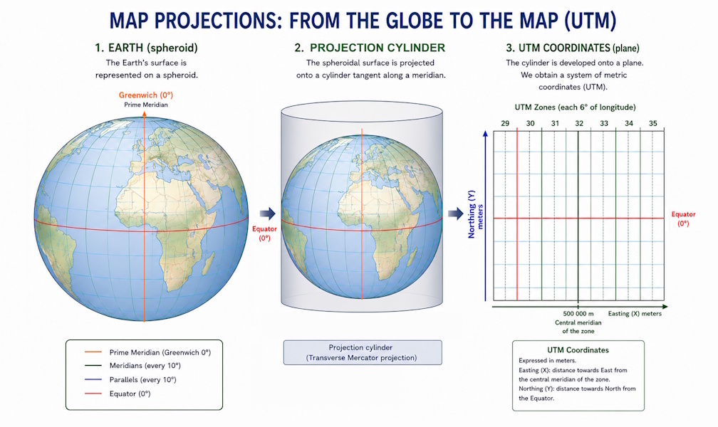
Example of a map projection: the Earth's surface is represented
on a plane using a cylindrical projection, such as the
Transverse Mercator projection used by the UTM system.
Do not confuse. A map projection is not the same
as a coordinate reference system (CRS). The projection describes
the mathematical method used to represent the Earth's surface on
a plane, while the CRS also includes the information required to
correctly interpret the coordinates.
Example.
The UTM projection is particularly suitable for representing areas
of limited extent with high metric accuracy, while Web Mercator is
widely used in online maps because of its practicality in managing
tiles, although it introduces increasingly large distortions at
high latitudes.
In OkMap. OkMap supports numerous map projections
and coordinate reference systems, allowing maps and geographic data
from different sources to be managed. For some formats, projection
information is part of the format itself, while in other cases it
can be associated through a PRJ file or by specifying the
corresponding reference system.
Definition. Ratio between a distance measured on
a map and the corresponding actual distance on the ground.
Details. Map scale is generally expressed as a
ratio, for example 1:25,000, meaning that one unit
of measurement on the map corresponds to 25,000 units of the same
measurement on the ground. For a map of the same physical size,
a larger scale (for example 1:10,000) represents a smaller area
with a higher level of detail, whereas a smaller scale
(for example 1:250,000) represents a larger area with a lower
level of detail.
Do not confuse with. Map scale should not be
confused with the zoom level of a digital map. Zoom changes only
the way the map is displayed, whereas scale expresses the ratio
between represented distances and actual distances.
In OkMap. OkMap automatically calculates the
display scale based on the zoom level, map resolution and
characteristics of the display device. It also allows measurements
to be made directly on the ground regardless of the map scale.
Definition. Tiled raster format based on an SQLite
database, designed to store maps divided into georeferenced tiles
within a single file.
Further information. The MBTiles format organizes
raster tiles in an SQLite database, allowing rapid access to the
data and efficient management of even very large maps. Thanks to
its simplicity and widespread adoption, it has become one of the
most widely used standards for distributing offline maps on mobile
devices and in cartographic applications.
Do not confuse with. Although it is also based on
SQLite, the MBTiles format should not be confused with RMaps SQLite
(.sqlitedb), which uses a different internal organization for tiles
and is intended for different applications.
In OkMap. OkMap supports reading and writing the
MBTiles format. It is also the format used by OkMap Mobile for
managing offline maps, allowing maps created with OkMap Desktop
to be transferred to mobile devices.
Definition. A coordinate representation system
that identifies the position of a point using a pair of
coordinates (East, North) expressed in metres.
Further information. Metric coordinates are a
particular application of Cartesian coordinates in the plane and
have meaning only within a specific coordinate reference system
(CRS). Identical coordinates can identify completely different
positions when interpreted according to different CRSs.
Not to be confused with. Metric coordinates do
not identify a specific coordinate reference system (CRS), but
simply represent coordinates expressed in metres, whose meaning
always depends on the CRS being used.
In OkMap. The metric coordinate system used
depends on the operational context: outside the context of a map,
the CRS set in Preferences is used, while within a map, the CRS
of the map itself is used.
Definition. Coordinate representation system
based on the UTM grid, used primarily in military applications,
but also widely used in civil protection, search and rescue, and
hiking cartography.
Further information. USNG is based on the
Universal Transverse Mercator (UTM) projection and uses an
alphanumeric notation that combines the UTM zone, the 100 km
square, and the metric coordinates within that square. Derived
from the MGRS (Military Grid Reference System), it represents the
version intended for civilian use in the United States. Position
accuracy depends on the number of digits used.
Example.
Colosseum (Rome) 33T TG 91958 40631
Do not confuse with. USNG is closely related to
the MGRS system and shares its basic structure, but uses some
conventions specific to civilian use in the United States.
In OkMap. OkMap allows MGRS coordinates to be
displayed, entered, and automatically converted to and from the
other supported coordinate representation systems.
The main directions used in navigation describe different
concepts that are often confused with one another. Understanding
their meaning is essential for correctly interpreting the
information provided by a GPS receiver, compass, or
mapping software.
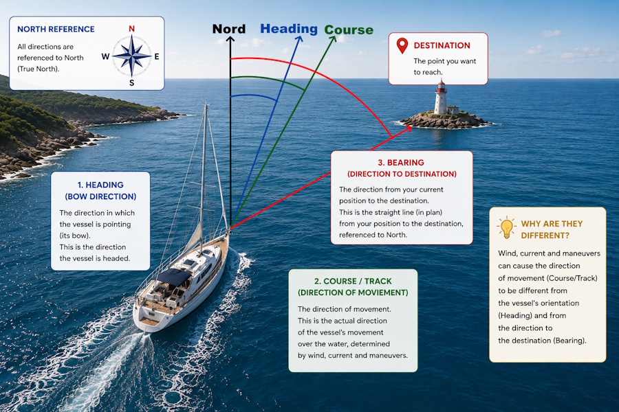
During navigation, the vehicle orientation (Heading), the actual
direction of movement (Course/Track), and the direction toward the
destination (Bearing) may be different.
The following figure shows the relationships between the main
concepts used in navigation, highlighting the differences between
vehicle orientation, direction of movement, and direction
toward a destination.
Definition. Communication standard used for
exchanging data between GNSS receivers, navigation instruments and
mapping software. Information is transmitted through text sentences
describing position, direction, speed, receiver status and other
navigation data.
Further information. The NMEA standard defines a
set of sentences, each dedicated to transmitting a specific type
of information. Each sentence is identified by a code, such as
RMC or GGA, and consists of fields
separated by commas.
In OkMap. OkMap can receive NMEA data from GNSS
receivers connected via a serial port or Bluetooth, from files
containing NMEA sentences, or from an integrated simulator. The
software supports the main sentences used for navigation:
RMC – minimum navigation data (position, date, time, speed and direction).
GGA – three-dimensional position and fix quality.
GLL – geographic position (latitude and longitude).
GSA – fix quality (DOP) and satellites used.
GSV – satellites in view.
HDT – heading relative to true north.
HDM – heading relative to magnetic north.
HDG – heading and magnetic variation.
VTG – course over ground (track made good) and ground speed.
Definition. Proprietary XML format used by OkMap
to save a map and the information required to reconstruct its
configuration and associated data.
Further information. An .okm file can contain
information relating to raster maps, web and local maps, the
reference system and projection, geographic and metric grids,
georeferencing, and vector data. It can also store graphic and
cartographic elements such as points, polylines, polygons, icons,
comments, and vector themes. The format is based on XML and uses
an XSD schema that defines its structure.
Do not confuse with. The .okm file is not a raster
or vector format intended for interoperability between cartographic
software applications. It is a proprietary format designed to
preserve the information used by OkMap for a map.
In OkMap. OkMap uses .okm files to save and reopen
maps together with their configuration and associated data. The
format therefore makes it possible to preserve in a single document
information that might otherwise be distributed across different
files and settings.
Definition. Open system for encoding geographic
coordinates that represents a location using an alphanumeric code,
without requiring an address or administrative references. It is
also known as a Plus Code.
Further information. An OLC code identifies a
specific area of the Earth's surface with a precision that depends
on the length of the code. It was developed by Google as an open
standard and is particularly useful in areas without postal
addresses or when a location needs to be quickly shared in a
compact form.
Example.
Colosseum (Rome) 8FHJVFRR+4W5
Do not confuse. An OLC code represents an encoded
geographic location and does not contain information about the
name of the place or its address. The same point can therefore be
identified both by geographic coordinates and by an OLC code.
In OkMap. OkMap allows coordinates to be displayed
and converted to OLC format, making it easier to share a location
using a compact and easily readable code.
Definition. Height of a point above the geoid,
which is used as an approximate reference for mean sea level.
Further information. Orthometric height represents
the elevation normally used in topographic mapping and in describing
terrain elevation. It is generally indicated by the letter H
and differs from ellipsoidal height because the latter is referenced
to the geodetic ellipsoid. The relationship between the two heights
depends on geoid undulation.
Do not confuse with. Orthometric height does not
coincide with the ellipsoidal height normally provided by GNSS
receivers. The two quantities have different reference surfaces
and may therefore have significantly different values.
In OkMap. Orthometric height is particularly relevant
when interpreting elevation data, but OkMap does not perform
transformations of the vertical reference system. The elevation
values contained in the data are used as provided by the source;
for SRTM data, for example, OkMap uses the model values directly,
while for GeoTIFF and ASCII Grid formats, data reading is handled
by GDAL.
Definition. Aerial or satellite image that has
been geometrically corrected to eliminate distortions caused by
perspective, terrain relief and sensor orientation, allowing
accurate cartographic measurements and overlay with other
geographic data.
Further information. Unlike a normal aerial
photograph, an orthophoto is georeferenced and has a uniform
scale throughout the image. Each pixel corresponds to a precise
geographic location on the Earth's surface. It can therefore be
used as a map, allowing distances, areas and coordinates to be
measured and other geographic data to be overlaid.
Do not confuse. An orthophoto is not simply an
aerial or satellite photograph. Only after the orthorectification
process does the image acquire the metric properties required
for use as a cartographic base.
In OkMap. Orthophotos can be used as georeferenced
raster maps, either on their own or overlaid with one or more web
maps. They are useful for route planning, georeferencing historical
maps and analyzing the territory.
Definition. XML-based vector format used by the
OpenStreetMap project to represent geographic data such as points,
lines, polygons and their associated attributes.
Further information. The OSM format describes
geographic elements using nodes (node), lines (way)
and relations (relation), to which attributes
(tag) describing their characteristics can be associated.
It is the native format of the OpenStreetMap project and is widely
used to exchange free and collaborative geographic data.
Do not confuse. The OSM format does not represent
a raster map, but a set of vector data that can be processed,
queried and graphically represented in different ways. It should
also not be confused with the maps displayed on the OpenStreetMap
website, which are one of the possible representations of the data.
In OkMap. OkMap supports importing OSM files,
converting the data into vector themes organized by type of
geographic element. The software also allows data to be downloaded
from OpenStreetMap and automatically converted into vector themes
or waypoints, for example for the displayed area or along a track.
Writing the OSM format is not supported.
Definition. Set of formats used by the OziExplorer
software to manage georeferenced maps, waypoints, routes and
tracks.
Further information. OziExplorer uses separate
files to store different types of data. The .map
file contains the georeferencing information for the raster map,
while the .wpt, .rte and
.plt files store waypoints, routes and tracks,
respectively. OziExplorer was one of the first software products
to popularize the use of georeferenced raster maps and GPS data
in hiking and outdoor navigation. For this reason, its formats are
still supported by many mapping applications today.
Do not confuse. The OziExplorer
.map file does not contain the raster map itself,
but only the information required to georeference it. The map
image is stored in a separate file referenced by the MAP file.
In OkMap. OkMap supports reading and writing
OziExplorer formats (.map, .wpt, .rte and .plt), allowing the
import and export of georeferenced maps, waypoints, routes and
tracks compatible with OziExplorer.
Definition. Point of interest identified by a
geographic location and descriptive information, such as its name,
category or other associated attributes.
Further information. POIs represent places
considered useful or significant, such as shelters, parking areas,
springs, summits, viewpoints, monuments or services. They can be
used as references during navigation, route planning or simply to
highlight places of particular interest.
Do not confuse. A POI generally identifies a place
of particular interest, while a waypoint more generally represents
a georeferenced point used as a reference. In practice, the two
terms are often used as synonyms.
In OkMap. OkMap uses GPX as its native format for
waypoints, routes and tracks. Since the GPX format does not
distinguish between POIs and waypoints, both are managed as
waypoints to which descriptive information, symbols, links and
other attributes can be associated. Points of interest downloaded,
for example, from OpenStreetMap can be imported and managed as
waypoints or converted into vector data organized in vector themes.
Definition. Degree of agreement between repeated
measurements of the same quantity obtained under the same
conditions.
Further information. A measurement is more precise
when the results of repeated observations are more similar to one
another, regardless of how close they are to the true value.
Precision depends primarily on the repeatability of the measuring
instrument and the acquisition conditions.
Example.
An instrument repeatedly measures the position of the same point,
obtaining nearly identical coordinates each time, but all shifted
by approximately 5 meters from the actual position. The measurements
are therefore very precise, but not very accurate.
Do not confuse. Precision describes how consistent
repeated measurements are with one another, while accuracy indicates
how close a measurement is to the true value.
In OkMap. The precision of displayed or recorded
positions depends primarily on the quality of the data provided by
the GPS/GNSS receiver and not on the software. OkMap uses this data
for its processing, while allowing the acquired information to be
displayed, analyzed and compared.
Definition. Text file that describes the
coordinate reference system (CRS) associated with a map or a set
of geographic data.
Further information. The PRJ file contains the
information required to correctly interpret the coordinates, such
as the datum, map projection and other parameters of the reference
system. It is commonly used together with several geographic data
formats, such as shapefiles.
Do not confuse. The PRJ file does not contain
cartographic or geographic data, but only the description of the
reference system used to interpret them.
In OkMap. OkMap uses the information contained in
PRJ files when available. If a map or geographic dataset does not
contain a description of its reference system, the software provides
tools to associate the correct CRS and, when necessary, generate the
corresponding PRJ file for use in subsequent processing.
Definition. Unit of angular measurement based on
the ratio between the length of an arc of a circle and its radius.
Further information. An angle of one radian subtends
an arc whose length is equal to the radius of the circle. A complete
angle corresponds to 2π radians, equivalent to 360°. Radians are the
unit of measurement used by most trigonometric functions and
mathematical libraries, making them particularly suitable for
scientific and cartographic calculations.
Do not confuse with. Radians and degrees measure
the same physical quantity, but use different units of measurement.
For example, 180° corresponds to π radians, while 90° corresponds to
π/2 radians.
In OkMap. OkMap internally uses radians for
geometric, geodetic and trigonometric calculations. Conversions
between radians and degrees are handled automatically, allowing the
user to display and enter angles in the desired unit of measurement.
Definition. Map representation model based on
a digital image composed of a regular grid of pixels, each of which
stores a color or, in some cases, a numerical value, such as
elevation.
Details. In raster format, each pixel corresponds
to an element of the image. This model is particularly suitable
for aerial photographs, satellite imagery, scans of paper maps,
and digital elevation models. Image quality depends on resolution,
while enlarging the image beyond its original resolution results
in a progressive loss of detail.
Not to be confused with. A raster format represents
a map using pixels, whereas a vector format represents objects
using geometric primitives such as points, lines, and polygons.
In OkMap. OkMap supports numerous raster formats,
both georeferenced and without spatial references. Non-georeferenced
images can be georeferenced using control points and subsequently
used within OkMap maps together with GPS data and vector data.
Definition. Map consisting of a digital image
formed by a grid of pixels, associated with geographic information
that allows it to be correctly positioned on the Earth's surface.
Further information. A raster map can be derived
from a scanned paper map, an orthophoto, a satellite image, or
other georeferenced images. Excessive enlargement can reveal the
pixel structure, resulting in a loss of visual quality.
Do not confuse with. A raster map should not be
confused with a vector map. In a raster map, information is
represented by pixels, whereas in a vector map it is described
using geometric objects such as points, lines, and polygons.
In OkMap. Raster maps are one of the main
cartographic supports used by OkMap. They can be georeferenced,
used as standalone maps, or overlaid on web maps. As with any
other type of map, they can be integrated with vector data and
other information layers managed by the software.
Definition. Tiled raster format based on an SQLite
database, used to store georeferenced maps divided into tiles within
a single file.
Further information. The RMaps SQLite format
organizes map tiles in an SQLite database, allowing fast access to
data and efficient management of large maps. It has been adopted by
numerous mapping applications for mobile devices thanks to the
simplicity of the format and its good performance for offline use.
Do not confuse with. Although it is also based on
an SQLite database, the RMaps SQLite format should not be confused
with MBTiles (.mbtiles), which uses a different internal tile
organization, or with the CompeGPS TwoNav (.rmap) format, which has
a completely different structure.
In OkMap. OkMap uses GDAL to read and write the
RMaps SQLite (.sqlitedb) format, allowing the import and export of
tiled raster maps compatible with applications that use this format.
Definition. Statistical measure of the overall error
associated with a set of values, calculated as the square root of
the mean of the squared errors.
Details. In georeferencing, the RMS error
(Root Mean Square) expresses the overall discrepancy between the
known coordinates of the control points and the coordinates obtained
by applying the transformation used. A lower RMS value generally
indicates a better fit of the transformation to the control points,
but does not necessarily guarantee greater map accuracy throughout
the entire map.
Not to be confused with. The RMS error measures
how well the transformation fits the points used to calculate it
and does not directly represent the absolute positional accuracy
of the map. A low RMS error may in fact result from inaccurate
control points or points that are distributed inadequately.
In OkMap. OkMap does not directly calculate or use
RMS error to evaluate georeferencing. The correct position of the
map can be verified using the tools provided by the software, for
example by displaying the metric grid on the map and comparing the
georeferenced map with external cartographic data, including by
overlaying it in Google Earth.
Definition. Ordered sequence of waypoints that
defines a planned path to follow in order to reach a destination.
Further information. A route consists of a set of
waypoints connected in a predefined order. Unlike a track, it does
not describe every point along the path, but only the significant
ones. The GPS device can use these waypoints as references during
navigation.
Do not confuse with. A route represents a planned
path and should not be confused with a track, which instead represents
a sequence of positions that have actually been traveled or drawn.
In OkMap. OkMap allows you to create, edit, import
and export routes, convert them to tracks and vice versa, and use
them for route planning. The software's autorouting features,
however, produce tracks, which are the format normally used during
outdoor navigation.
Definition. Process of calculating an optimal route
between two or more locations using the available road or trail
network.
Further information. Routing determines the most
appropriate path based on the waypoints specified by the user and
the available transportation network data. Depending on the service
used, different criteria may be considered, such as distance,
travel time or route type.
Do not confuse with. Routing calculates a path
along an existing road or trail network. It should not be confused
with manually drawing a track or with autorouting, which automates
the construction of a track while selecting waypoints.
In OkMap. OkMap uses the openrouteservice
routing service provided by HeiGIT, which requires an API key.
The user defines a sequence of waypoints on the map or by entering
their coordinates; the service automatically calculates the route
along the available road or trail network, including trails present
in the service data, and returns it as a track.
Definition. Image of the Earth's surface
acquired by sensors installed aboard artificial satellites.
Further information. Satellite images are used
for observing the Earth's surface, environmental monitoring,
agriculture, cartography and many other applications. They can
be acquired in different spectral bands and at different
spatial resolutions.
Not to be confused with. A satellite image is
not necessarily an orthophoto. An orthophoto is an image that
has been geometrically corrected to eliminate distortions caused
by terrain relief and perspective, so that it can be used as a map.
In OkMap. OkMap allows georeferenced satellite
images to be used as raster maps. When an image is not
georeferenced, it can be georeferenced manually.
Definition. Satellite-based augmentation system
that improves the accuracy, reliability and integrity of positioning
obtained from GNSS systems by transmitting correction information
and data concerning the reliability of navigation signals.
Details. An SBAS uses a network of ground stations
to monitor GNSS signals and determine corrections and integrity
information. This data is then transmitted to users through
geostationary satellites and can be used by compatible receivers
to improve positioning performance. Several SBAS systems exist,
each serving different geographic areas.
Do not confuse with. SBAS is not an independent
GNSS system such as GPS or Galileo, but a complementary system
that improves the information provided by GNSS systems. EGNOS is
the European SBAS.
In OkMap. OkMap uses the coordinates provided by
the GNSS device and does not directly manage the SBAS system.
The use of SBAS corrections and the resulting improvements in
positioning depend on the GNSS receiver and its configuration.
Definition. Geometric transformation that modifies
the position, orientation, and scale of a figure without altering
its shape.
Overview. In a two-dimensional similarity
transformation, translation, rotation, and uniform scaling are
possible. The same scale is applied in the different directions,
so angles and length ratios are preserved. The transformation can
therefore move, rotate, and resize a map without deforming it.
Not to be confused with. A similarity transformation
is a special case of an affine transformation. Unlike the latter,
it does not allow different scales in different directions or shear
deformation.
In OkMap. OkMap uses the similarity transformation
in georeferencing procedures with two control points. The two points
make it possible to determine the translation, rotation, and uniform
scale required for the transformation.
Definition. Measure of the inclination of a
surface or section of terrain relative to the horizontal plane.
It can be expressed as a percentage or in degrees.
Further information. Slope expressed as a percentage
indicates the ratio between the vertical elevation difference and
the horizontal distance, multiplied by 100. For example, an
elevation difference of 10 meters over a horizontal distance of
100 meters corresponds to a slope of 10%.
Slope expressed in degrees instead indicates the angle formed by
the surface with the horizontal plane. The two measurements are
therefore related but do not coincide: a slope of 100% corresponds
to an inclination of 45°, while a slope of 10% corresponds to
approximately 5.7°.
The conversion between the two representations is based on the
trigonometric relationship between the elevation difference and
the horizontal distance. If p is the slope expressed as
a percentage and α is the inclination angle, the
relationship is:
p = 100 × tan(α)
To obtain the angle from the percentage slope, the arctangent is
therefore used:
α = arctan(p / 100)
Do not confuse. A slope expressed as a percentage
does not represent an angle: a value of 100% does not correspond
to 100°, but to 45°. A vertical surface would theoretically have
an infinite percentage slope and an inclination of 90°.
In OkMap. OkMap uses elevation data to calculate
terrain slope. Track statistics report both slopes expressed as
percentages and those expressed in degrees, also distinguishing
between average uphill and average downhill slopes. The values can
therefore be interpreted both as the percentage ratio between
elevation difference and horizontal distance and as the terrain's
inclination angle.
Definition. Digital terrain model format used by
the Shuttle Radar Topography Mission (SRTM) to distribute elevation
data for the Earth's land surface.
Details. The SRTM mission, carried out in February
2000 aboard the Space Shuttle Endeavour, acquired elevation data
covering most of the Earth's land surface using synthetic aperture
radar. The data is distributed in .hgt files,
each covering a geographic area of 1°×1° of latitude and longitude.
Resolution varies depending on the dataset used, for example SRTM1
(approximately 30 metres) and SRTM3 (approximately 90 metres).
Do not confuse with. SRTM identifies the project
that produced the elevation data, whereas HGT (.hgt)
is the format used to store it. Other digital terrain models also
exist, produced using different techniques and resolutions.
In OkMap. OkMap uses SRTM data to calculate
elevation profiles, track statistics, slopes, visibility analyses
and three-dimensional visualizations. When necessary, the software
can automatically download the required SRTM files and use them
for elevation-related processing.
Definition. A small portion of a map used to divide
a cartographic representation into smaller and easily manageable
elements.
Overview. In most mapping applications, a tile
consists of a raster image of a fixed size (for example, 256×256 or
512×512 pixels), organized according to a grid and associated with a
specific zoom level. This approach makes it possible to display and
transfer only the portions of the map that are actually needed,
improving performance and reducing memory and bandwidth consumption.
Not to be confused with. A tile represents only a
small part of a map and is not a cartographic format. Formats such
as MBTiles, JNX, Garmin Custom Map, and RMaps SQLite instead store
organized collections of tiles.
In OkMap. OkMap uses tiles to manage web maps and
to create numerous tiled raster map formats, such as MBTiles, JNX,
Garmin Custom Map, CompeGPS TwoNav, and RMaps SQLite. For some
formats, the software also allows the size and organization of tiles
to be optimized.
Definition. Conventions used to identify and request
map tiles by means of the zoom level and grid indices.
Overview. In TMS and XYZ systems, each tile is
identified by the zoom level (z) and the grid coordinates
(x and y). The main difference between the two
conventions concerns the numbering of the vertical axis, while the
methods used to access the data remain essentially similar. TMS and
XYZ are widely used by Web mapping services to distribute maps
divided into tiles.
Not to be confused with. TMS and XYZ are not file
formats, but conventions used by mapping services to identify and
request the tiles that make up a map.
In OkMap. OkMap handles TMS and XYZ services
transparently, identifying them generically as XYZ services. The
method used to access the tiles is determined by the service URL,
which defines how the tiles must be requested, without requiring
different configurations from the user.
Definition. Tiled raster format used by TomTom
navigation devices to store georeferenced maps divided into tiles.
Overview. The TomTom (.sat) format organizes a
raster map into a set of tiles, allowing the navigation device to
quickly display only the portions required during use. This approach
reduces data access times and improves performance when managing
large maps.
Not to be confused with. The TomTom (.sat) format
should not be confused with other tiled raster formats, such as
MBTiles, JNX, Garmin Custom Map, or RMaps SQLite, which use different
internal structures while pursuing the same objective.
In OkMap. OkMap allows georeferenced maps to be
exported in the TomTom (.sat) format, automatically generating the
tiles required by compatible devices. Reading this format is not
supported.
Definition. A geographic map that represents in
detail the natural and man-made features of a portion of the
Earth's surface.
Further information. A topographic map shows
features such as terrain, waterways, roads, trails, buildings,
vegetation and contour lines, making it possible to describe
the morphology and characteristics of the territory in detail.
It is one of the fundamental tools for hiking, route planning,
navigation and surveying activities.
Not to be confused with. A topographic map is a
particular type of geographic map characterized by a detailed
representation of the territory.
In OkMap. OkMap allows the use of
georeferenced raster topographic maps together with GPS data,
tracks, waypoints and other information layers.
Definition. Discipline concerned with surveying and
detailed representation of the Earth's surface and the natural and
artificial features that characterize it.
Overview. Topography encompasses the techniques used
to determine the planimetric and altimetric position of points on the
ground and to represent them using maps, digital models, or other
cartographic products. Today, topographic surveying is carried out
using instruments such as GNSS receivers, total stations, laser
scanners, and drones.
Not to be confused with. Topography should not be
confused with cartography. Topography deals with surveying and
measuring the territory, while cartography concerns the representation
of geographic information using maps.
In OkMap. OkMap provides tools for acquiring,
analyzing, and representing topographic data, allowing maps, GPS data,
digital terrain models, and georeferenced surveys to be managed within
a single working environment.
Definition. Ordered sequence of georeferenced points
describing a recorded, generated, or drawn route.
Overview. A track consists of a series of
georeferenced points, generally acquired at time or distance
intervals. Each point may contain information such as position,
elevation, date, and time. Unlike a route, a track describes the
path in detail, closely following its actual course.
Not to be confused with. A track should not be
confused with a route. A route consists of a sequence of waypoints
defining an itinerary, while a track contains all the points
describing the path that was actually recorded or planned.
In OkMap. The track is one of the central elements
for managing itineraries. OkMap allows tracks to be recorded, created,
edited, analyzed, merged, split, filtered, optimized, and converted,
as well as providing statistics, elevation profiles, visibility
analysis, and numerous other processing functions.
Definition. Conformal cylindrical map projection
obtained by positioning the cylinder tangent to (or secant along)
a meridian rather than along the equator.
Overview. The Transverse Mercator projection
preserves angles and local shapes while also keeping distance
distortions limited near the central meridian. For this reason,
it is particularly suitable for representing territories extending
predominantly in a north-south direction. Distortions progressively
increase with distance from the central meridian, which is why this
projection is generally used by dividing the Earth's surface into
zones. Its most widespread application is the Universal Transverse
Mercator (UTM) system, which is widely used in cartography and GPS
navigation systems.
Not to be confused with. The Transverse Mercator
projection is not the same as the UTM system. UTM uses the
Transverse Mercator projection by dividing the Earth into zones,
each with its own central meridian and specific cartographic
parameters.
In OkMap. OkMap supports coordinate reference
systems based on the Transverse Mercator projection, allowing maps
and geographic data to be displayed, georeferenced, and converted
between different coordinate systems.
Definition. Direction of the geographic North Pole,
used as a reference in geographic coordinate systems and
cartography.
Further information. True north corresponds to
the direction of the geographic meridian passing through the
observation point. Unlike magnetic north, it is not affected by the
Earth's magnetic field and is the reference used by most maps. The
angle relative to magnetic north is called
magnetic declination.
Do not confuse with. True north should not be
confused with magnetic north, which is indicated by a compass
needle and is subject to magnetic declination.
In OkMap. OkMap uses true north as a cartographic
reference and can also handle heading information referenced to
true north received through NMEA sentences.
Definition. Coordinate reference system used in
the United States to uniquely identify the position of a point
using a metric grid.
Overview. USNG is based on the Universal Transverse
Mercator (UTM) projection and uses an alphanumeric notation that
combines the zone number, grid identifier, and Easting and Northing
coordinates. Derived from the MGRS (Military Grid Reference System),
it represents the version intended for civilian use in the United
States. Thanks to its hierarchical structure, it allows a position
to be expressed at different levels of precision and is widely used
in cartography, civil protection, and emergency services.
Example.
Colosseum (Rome) 33T TG 91958 40631
Not to be confused with. USNG is not the same as
the UTM system. Both are based on the same map projection, but USNG
uses an alphanumeric representation designed to simplify the
identification and communication of positions.
In OkMap. OkMap supports the USNG system for
displaying and entering coordinates, automatically converting them
to and from the other supported coordinate and coordinate
representation systems.
Definition. Metric coordinate system based on the
Transverse Mercator map projection, used to represent the Earth's
surface using Easting (Easting) and Northing (Northing) coordinates.
Overview. The UTM system divides the Earth, between
latitudes 80° S and 84° N, into 60 zones, each 6° of longitude wide
and characterized by its own central meridian. Within each zone,
coordinates are expressed in meters using a metric grid referenced
to the zone's central meridian, making the calculation of distances,
areas, and directions straightforward. Thanks to the limited
distortions introduced by the Transverse Mercator projection, UTM
is one of the most widely used coordinate systems in cartography,
surveying, and GPS navigation.
Example.
Colosseum (Rome) Zone 33N Easting = 291958 m Northing = 4640631 m
Not to be confused with. UTM is not the same as the
Transverse Mercator projection. The latter is the map projection on
which the UTM system is based, whereas UTM also defines the division
of the Earth into zones and the rules for representing coordinates.
In OkMap. OkMap fully supports the UTM system,
allowing coordinates to be displayed, entered, and automatically
converted to and from the other supported coordinate and coordinate
representation systems.
Definition. Each of the 60 bands of 6° of
longitude into which the UTM system divides the Earth's surface
to represent metric coordinates.
Details. Each UTM zone is identified by a
number from 1 to 60, numbered from west to east starting at the
180° meridian. The zones extend between latitudes 80° S and
84° N and are associated with their own central meridian, on
which the Transverse Mercator projection used by the UTM system
is based.
Example.
Colosseum (Rome) UTM Zone = 33N
Do not confuse. The UTM zone identifies the
sector of the Earth in which the metric coordinates are
expressed. The zone number and the corresponding latitudinal
band are not coordinates themselves, but form part of the
complete identification of a position in the UTM system.
In OkMap. OkMap uses the UTM zone to display,
enter, and convert metric coordinates. When converting from
other coordinate systems, the zone is determined automatically
from the geographic position, whereas when UTM coordinates are
entered manually, the zone must be specified by the user. To
distinguish the two hemispheres, the software uses the
N (North) and S (South)
convention.
Definition. Map representation model based on
geometric primitives, such as points, lines, and polygons,
described by coordinates and associated attributes.
Details. Unlike raster images, vector objects
are described by coordinates and associated attributes and can be
enlarged or reduced without loss of quality. Vector formats are
particularly suitable for representing elements such as roads,
trails, boundaries, buildings, and other geographic objects.
Not to be confused with. A vector format describes
objects using coordinates and geometric primitives, whereas a
raster format represents them as a digital image composed of pixels.
In OkMap. OkMap organizes vector data into
themes, each with its own graphical characteristics. In addition
to standard geometric primitives (points, multipoints, polylines,
and polygons), it also supports its own graphical objects, such as
arcs, pies, comments, and icons. Vector data is stored in the
map CRS, avoiding coordinate conversions during display.
Definition. Map in which terrain features are
represented by geometric objects, such as points, lines, and
polygons, described using coordinates and attributes rather than
pixels.
Further information. Vector maps make it possible
to represent territory with high geometric precision and can be
displayed at different scales without loss of quality. Objects
can also be associated with descriptive information, such as names,
categories, or other properties.
Do not confuse with. A vector map should not be
confused with a raster map. In a vector map, the territory is
described using geometric objects, whereas in a raster map it is
represented by an image composed of pixels.
In OkMap. OkMap allows vector maps consisting
exclusively of vector data to be created and managed, within their
geographic extent (bounding box). The same vector data
can also be used to integrate raster maps and web maps, maintaining
a single data management model regardless of the type of
cartographic support used. In all cases, vector data are organized
into vector themes, which define their graphical characteristics,
labeling, drawing order, and display scale.
Definition. A homogeneous set of vector elements
belonging to the same category and represented with common graphic
characteristics.
Overview. A vector theme can contain points, lines,
or polygons describing a specific type of geographic feature, such
as roads, trails, buildings, waterways, or contour lines. Organizing
data into separate themes makes it easier to display, select, edit,
and analyze them.
Not to be confused with. A vector theme is not a
file format. The same theme can be imported or exported in different
vector formats, such as Shapefile, GeoJSON, or KML.
In OkMap. OkMap organizes vector data into themes,
each containing homogeneous elements in terms of geometric type
and meaning. Each theme can be displayed, edited, queried, and
managed independently of the others, while retaining its own graphic
and informational characteristics. When importing certain formats,
such as OpenStreetMap, OkMap automatically creates a separate theme
for each type of geographic feature, simplifying data management and
consultation.
Definition. Satellite-based augmentation system
(SBAS) developed to improve the accuracy, integrity and
reliability of positions determined by GPS.
Details. WAAS uses a network of ground reference
stations that calculate GPS positioning errors and transmit the
corresponding corrections to geostationary satellites. Compatible
receivers can therefore obtain more accurate positions without
requiring additional equipment. WAAS is used mainly in North America
and is one of the most widely used SBAS systems.
Not to be confused with. WAAS does not replace GPS,
but improves its performance by applying corrections to positioning
data. Similar systems include EGNOS in Europe and MSAS in Japan.
In OkMap. OkMap automatically uses the coordinates
provided by the GPS receiver, including those potentially corrected
using SBAS systems such as WAAS, without requiring specific software
configuration.
Definition. Georeferenced point used to identify
a location of interest by means of its coordinates.
Details. A waypoint represents a significant
location, such as a mountain hut, summit, parking area, spring or
any other point of interest. In addition to geographic coordinates,
it may contain additional information such as name, description,
symbol, elevation, date and other descriptive attributes. A
waypoint identifies a location but does not provide information
about the route to follow to reach it.
Not to be confused with. A waypoint identifies a
single location, whereas a route consists of a sequence of waypoints
and a track consists of an ordered sequence of points describing a
path.
In OkMap. OkMap allows you to create, edit, manage,
import, export and convert waypoints, associating symbols,
descriptions, links, images and other information with each one.
Waypoints can also be imported from OpenStreetMap, used to create
routes, generate tracks through autorouting and represent points of
interest on the map.
Definition. Map distributed through a service
available online, which provides cartographic data on request and
allows it to be displayed through an Internet connection.
Further information. Web maps can consist of
raster images divided into tiles or vector data generated
dynamically by the remote service. Many services also allow
information to be organized into selectable layers, which can be
displayed individually or combined.
Do not confuse with. A web map is not the same as
a web mapping website. The map is the cartographic content provided
by the service, while the website is the interface through which
the user accesses it.
In OkMap. Web maps are one of the main cartographic
supports used by OkMap. A web map can consist of one or more layers
from the same service or from different services, each of which can
be displayed with its own transparency level. Where supported by
the service, layers can be selected and combined by the user to
obtain different cartographic representations. One or more
georeferenced raster maps can also be overlaid on the web map.
As with any other type of map, it can be integrated with vector
data and other information layers managed by the software.
Definition. Service accessible through a computer
network that allows maps and geographic data to be viewed, queried
or processed without having to store them locally.
Details. A Web mapping service provides maps,
geographic data or geospatial functionality through standard
protocols. Depending on the type of service, it may provide raster
maps, access to vector data, map tiles, geographic searches
(geocoding) or route calculation (routing). Common services
include WMS, WMTS and TMS/XYZ.
Do not confuse with. A Web mapping service is not
a file format, but a resource accessible over a network. Data may
be processed dynamically or transferred to the client in different
ways, depending on the type of service.
In OkMap. OkMap supports numerous Web mapping
services for displaying online maps, downloading geographic data
and using features such as geocoding, routing and points of
interest search. The software also provides a list of predefined
services and allows users to add new custom Web mapping services,
specifying their characteristics and access parameters.
Definition. Map projection used by most Web
mapping services to display maps online.
Details. Web Mercator is a variant of the Mercator
projection based on the WGS84 datum. Thanks to its computational
simplicity and the division of the map into tiles, it has become
the standard adopted by most Web mapping services. Although it
preserves angles and local shapes, it introduces distortions in
distances and areas that increase progressively with latitude.
For this reason, distances measured directly on the Web Mercator
grid do not necessarily correspond to actual ground distances,
especially at high latitudes.
Not to be confused with. Web Mercator is not the
same as the classical Mercator projection. Although it is directly
derived from it, it uses a simplified formulation that makes it
particularly suitable for managing digital maps and Web mapping
services.
In OkMap. OkMap uses the Web Mercator projection
to display maps from most Web mapping services and automatically
handles conversions to the other coordinate reference systems
supported by the software.
Definition. Geodetic reference system used by
GPS and numerous mapping applications to define the position of
points on the Earth's surface.
Details. WGS84 defines a global geodetic datum
based on a mathematical ellipsoid that approximates the shape of
the Earth. It is the reference system adopted by GPS and is today
the international standard for most navigation, mapping and
georeferencing applications. Geographic coordinates (latitude and
longitude) without a specified datum are, in most GPS applications,
assumed to refer to WGS84.
Not to be confused with. WGS84 is neither a
coordinate system nor a map projection. It is a geodetic reference
system on which different coordinate systems can be defined, such
as geographic coordinates or the UTM system.
In OkMap. WGS84 is the default reference system
used for GPS and provides the basis for displaying, importing,
exporting and converting coordinates between the numerous reference
systems supported by the software.
Definition. WKT (Well-Known Text) is a text format
used to describe coordinate reference systems (CRS), projections,
datums and other components of geodetic and mapping systems in a
structured way.
Details. The WKT format allows the information
defining a coordinate system to be represented in a readable text
form that can be used by mapping software. Several versions and
variants of the format exist: WKT1 is the historically most widely
used version, while WKT2 is the newer and more structured standard,
defined by the Open Geospatial Consortium (OGC) and subsequently
updated.
WKT can describe both geographic coordinate systems, based on
longitude and latitude, and projected coordinate systems, based on
planar coordinates. The representation can therefore contain
information about the datum, ellipsoid, projection, measurement
units and other parameters required to define the CRS.
Coordinate reference system definitions can be saved in files with
the .prj extension, which normally contain the CRS
description in WKT format. The .prj file is used together with the
geographic data to which it refers and must be available when
importing data that requires an external coordinate reference system
definition, such as vector data or raster maps associated with a
World File.
Not to be confused with. WKT is not a coordinate
system and does not define a particular projection: it is a format
used to describe a CRS and its components. WKT1 and WKT2 also
represent different versions of the standard and may differ in
structure and in the information they contain.
In OkMap. OkMap can generate the WKT description
of the CRS in use, both for geographic coordinate systems
(GEOGCS) and projected coordinate systems
(PROJCS). It is possible to choose between different
formats and representation variants, including WKT1, WKT2,
WKT2:2015, WKT2:2019 and specific variants such as WKT ESRI,
as well as other representations supported by the function,
including PROJ.4 and PROJJSON.
When OkMap writes data that requires an external definition of the
coordinate reference system, it can also generate the corresponding
.prj file. When reading data, the presence of the .prj file
is necessary to correctly interpret the coordinate reference system
when it is not contained directly in the format.
Definition. Web mapping service standardized by
the Open Geospatial Consortium (OGC) that allows maps generated
dynamically over the Internet to be displayed.
Details. A WMS service produces map images in
response to client requests, generating them dynamically according
to the geographic area, coordinate reference system, scale, layers
and other requested parameters. Maps are generally returned in
common raster formats such as PNG or JPEG and can be overlaid with
other cartographic data.
Not to be confused with. WMS does not transmit
predefined tiles, but generates each image when requested. It is
therefore different from WMTS and TMS / XYZ services, which are
instead based on pre-generated tiles.
In OkMap. OkMap supports WMS services, allowing
them to be added to the list of Web mapping services, their maps
to be displayed, overlaid with other cartographic data and used
together with the other tools provided by the software. The
software also allows custom WMS services to be configured by
specifying their access parameters.
Definition. Web mapping service standardized by
the Open Geospatial Consortium (OGC) that distributes maps using
pre-rendered tiles.
Details. Unlike a WMS service, a WMTS service does
not dynamically generate the requested image, but returns
pre-generated tiles organized by zoom level. This approach provides
very fast response times and reduces the processing load on the
server. Tiles are organized in a hierarchical structure by zoom
level, allowing large maps to be displayed quickly without having
to transfer the entire image.
Not to be confused with. WMTS uses pre-rendered
tiles, whereas WMS generates each image when requested. TMS / XYZ
services also use tiles, but adopt different conventions for their
organization and access.
In OkMap. OkMap supports WMTS services, allowing
them to be added to the list of Web mapping services, their maps
to be displayed, overlaid with other cartographic data and used
together with the other tools provided by the software. The
software also allows custom WMTS services to be configured by
specifying their access parameters.
Definition. Text file associated with a raster
image that describes its georeferencing, allowing it to be correctly
positioned in geographic space.
Details. A World File contains six parameters that
define the position, scale, rotation and pixel size of the image.
It does not modify the image content, but specifies only its
geographic positioning. The World File extension depends on the
associated image format, for example TFW (TIFF), JGW (JPEG), PGW
(PNG) and BPW (BMP).
Not to be confused with. A World File does not
contain the image data or the coordinate reference system (CRS),
which must be known or specified separately. Unlike GeoTIFF formats,
georeferencing is stored in a separate file.
In OkMap. OkMap reads and writes World Files
associated with raster images, allowing maps to be georeferenced,
imported, exported and used together with the other cartographic
data supported by the software. To read an image georeferenced
using a World File, the corresponding PRJ file containing the
coordinate reference system (CRS) of the image must also be
available.
Definition. Markup language used to represent
structured data in text format by means of elements organized in
a hierarchical structure.
Details. XML (eXtensible Markup Language)
describes the structure and content of data through freely
definable tags. Thanks to its flexibility and readability,
it is widely used for exchanging information between
applications and forms the basis of numerous formats, including
GPX and KML.
Do not confuse. XML defines the structure of
data, but not its meaning. Each application interprets the
content according to the schema or specifications of the format
being used.
In OkMap. OkMap uses XML as the base format
for several geographic files, including GPX and KML. The
software also supports proprietary extensions of the GPX format
to store additional information while maintaining compatibility
with the standard. XML is also used for storing numerous
proprietary OkMap formats based on XML, including maps (.okm),
photos (.pho), place names (.top), and other application data.
Definition. Operation that changes the
magnification or reduction level of a map display, allowing
the territory to be viewed with a different degree of detail.
Details. Zoom does not modify the map data,
but only their representation on the screen. Increasing the
zoom level displays more detail, while decreasing it provides
a broader view of the territory. The way zoom is managed
depends on the type of map being used.
Do not confuse. Zoom is not the same as
cartographic scale. Scale represents the ratio between
distances on the map and actual distances on the ground,
whereas zoom determines the magnification level at which the
map is displayed.
In OkMap. OkMap uses different zoom methods
depending on the type of map being used. For raster maps,
zoom is expressed as a percentage of image magnification. For
Web mapping services, zoom corresponds to the zoom levels
provided by the service (in OkMap from 4 to 20). For pure
vector maps, zoom is expressed by the display resolution,
indicated in meters per pixel (m/pixel), which directly
represents the ground distance corresponding to one screen
pixel.
Would you like to apply these concepts with OkMap?
After reading the technical articles, you can learn more through the practical video
tutorials or download OkMap Desktop and work directly with maps, GPX tracks, and GPS data.