Why are there different coordinate systems in Italy?
Contrary to what many people might think, there is no single coordinate system used by all maps in Italy. This situation is the result of the evolution of Italian cartography over more than a century, driven by very different needs: the production of official national maps, regional technical mapping, cadastral management and, more recently, satellite navigation and GPS technology.
Over time, several cartographic systems were introduced and became established, each characterized by its own reference system and coordinate system. Each one was designed to meet specific requirements and is often closely linked to the historical period in which it was adopted. As a result, maps and geographic databases representing the same territory may still use different coordinate systems today.
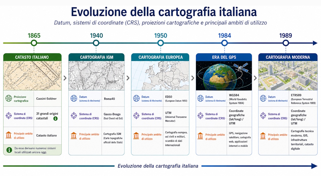
Italian cartography evolved through three major historical branches, each created in a different period to meet specific needs and each based on its own reference systems, map projections and methods of representing the territory.
- the cartography of the Istituto Geografico Militare (IGM), which represented Italy's official national mapping for more than a century and remains the historical reference for much of Italian cartography today;
- Regional Technical Cartography (CTR), developed by the regional administrations for land-use planning, infrastructure design and territorial management;
- cadastral mapping, created for the identification, registration and management of real estate properties.
Understanding how these three branches evolved helps explain why different coordinate systems and geodetic datums still coexist in Italy today. Many historical and technical maps still use systems such as Gauss-Boaga, Roma40, ED50 or Cassini-Soldner, while modern GPS devices normally operate in the WGS84 reference system. To use maps from different sources correctly, it is therefore essential to know the coordinate system in which they were produced.
The cartography of the Istituto Geografico Militare (IGM)
To understand Italian cartography, it is necessary to begin with the Istituto Geografico Militare (IGM), the institution that produced Italy's official national maps for more than a century. Its topographic maps became the reference for public administrations, professionals, hikers and researchers, forming the foundation on which much of the country's later cartography was built. Many hiking and tourist maps available today are directly or indirectly derived from this cartographic heritage.
To represent the entire national territory accurately, the IGM adopted the Gauss-Boaga coordinate system, based on the Roma40 datum, which remained the standard for Italian cartography for many decades.
Even today, it is common to encounter IGM maps or other cartographic products that use Gauss-Boaga coordinates. For this reason, understanding this system remains important both when working with historical documents and when comparing maps produced in different periods with modern GPS data.
Why Gauss-Boaga became the Italian standard
For many decades, the Gauss-Boaga coordinate system was the standard used throughout Italian cartography. Its widespread adoption was not accidental: it allowed the national territory to be represented with high accuracy and was perfectly suited to the production of IGM topographic maps.
Thanks to its reliability, the system was also adopted by numerous public administrations and organizations producing technical maps. As a result, maps, archives and geographic databases using Gauss-Boaga coordinates are still common today, despite the widespread adoption of modern reference systems used by GPS receivers.
Regional Technical Cartography (CTR)
Starting in the 1970s, alongside the official mapping produced by the IGM, the Italian regions began creating their own Regional Technical Cartography (CTR) for urban planning, infrastructure design, land management and civil protection.
Compared with traditional topographic maps, CTR was designed to provide a much higher level of detail, accurately representing buildings, roads, waterways, administrative boundaries and many other features required for technical and administrative activities.
Over the years, different regions adopted different coordinate systems. Many of the earliest CTR datasets were produced using the Gauss-Boaga / Roma40 system, while others adopted UTM coordinates based on the ED50 datum. More recently, cartographic production has progressively shifted toward modern reference systems such as ETRS89 and WGS84, following European standards and the widespread adoption of GPS technology.
This evolution explains why Regional Technical Cartography is still available today in different coordinate systems, often making coordinate transformations necessary when integrating data from different sources.
The Cadastre and the Cassini-Soldner system
A third important branch of Italian cartography is cadastral mapping, which was created for purposes quite different from those of topographic cartography. Its primary objective was not to represent the territory for navigation or geographic studies, but to identify and manage real estate properties.
For this reason, the Italian Cadastre adopted the Cassini-Soldner system, which is particularly suitable for accurately representing relatively small areas. Each cadastral zone has its own projection origin, minimizing local distortions—an essential requirement for land subdivision and property boundary definition.
Unlike the Gauss-Boaga system, which was designed to represent the entire national territory, Cassini-Soldner is mainly used for cadastral maps. Much of the cadastral documentation still relies on this coordinate system today, making coordinate conversion necessary when integrating cadastral data with technical maps, IGM maps or GPS data.
ED50 and the introduction of UTM coordinates
After World War II, the need arose for a common European reference system that would provide greater consistency in cartographic production and facilitate data exchange between different countries.
This led to the introduction of the ED50 (European Datum 1950), based on a geodetic network covering much of Western Europe. In Italy, its use gradually expanded, particularly in technical mapping and in many civil and military applications.
Together with ED50, the UTM (Universal Transverse Mercator) coordinate system also became widespread. UTM divides the Earth's surface into zones of constant width, simplifying map representation and making it easier to exchange geographic data between different countries.
For many years, the ED50/UTM system coexisted with the Gauss-Boaga/Roma40 system. Even today, maps, geographic databases and technical documentation using ED50 coordinates are still common, making conversion to more modern reference systems frequently necessary.
The arrival of GPS: WGS84 and ETRS89
The widespread adoption of GPS receivers introduced a new reference system that would become the global standard: WGS84 (World Geodetic System 1984). Unlike the historical systems used in Italian cartography, WGS84 was designed to represent the entire Earth and is still the reference system used today by GPS receivers, smartphones, most navigation services and many web mapping platforms.
At the same time, European countries progressively adopted ETRS89 (European Terrestrial Reference System 1989), the reference system used for modern technical cartography and many national geospatial infrastructures. In Italy, many geographic databases and the most recent maps are now distributed in this system.
Although they are very similar in everyday use, WGS84 and ETRS89 were designed for different purposes: the former is a global reference system, while the latter was specifically defined to ensure the long-term stability of European cartography.
However, the gradual adoption of WGS84 and ETRS89 did not immediately replace the older systems. As a result, it is still common today to integrate data from historical Gauss-Boaga or Roma40 maps with information collected using GPS or obtained from modern technical cartography.
Although they serve different purposes, in most cartographic and GPS applications WGS84 and ETRS89 can be considered practically equivalent, since the differences between the two systems are generally on the order of a few decimeters across Europe. Only high-precision geodetic applications require these differences to be taken into account.
Why do so many coordinate systems still coexist today?
The coexistence of systems such as Gauss-Boaga, Roma40, ED50, Cassini-Soldner, UTM, WGS84 and ETRS89 is not the result of a lack of standardization, but the natural consequence of the evolution of Italian cartography.
Each system was developed within a specific historical context to meet particular needs: from the IGM's national cartography to Regional Technical Cartography, cadastral management and, more recently, the widespread use of GPS receivers and Geographic Information Systems (GIS).
Because many cartographic archives still use these systems today, coordinate transformation is an essential task when integrating maps from different sources or comparing historical data with modern surveys.