What does it mean to orient a map?
A map is oriented when it is positioned so that the directions represented on the map correspond to the actual directions of the terrain. In practice, if North is shown at the top of the map, orienting the map means rotating it until its North actually points towards North.
Once the map is oriented, it becomes much easier to compare what we see on the map with what we observe around us: a valley, a ridge, a road, a building or a summit can be identified in the correct direction.
To learn how to correctly interpret a topographic map, including its legend, scale, grids, coordinates and contour lines, see the article How to read a topographic map.
True North and Magnetic North
When discussing orientation, it is important to distinguish between True North and Magnetic North.
True North indicates the direction towards the geographic North Pole and is the reference used by geographic cartography. Magnetic North is instead the direction indicated by a compass needle, determined by the Earth's magnetic field.
The two directions do not coincide exactly. The angular difference is called magnetic declination and varies over time and according to geographic location.
When using a compass together with a map, it is therefore necessary to know which North reference the map uses and, when necessary, take magnetic declination into account. Topographic maps may provide this information in the legend or in a dedicated diagram.
Orienting the map with a compass
The simplest method for orienting a map is to use a compass. Place the compass on the map and rotate the map until the North direction on the map coincides with the direction indicated by the compass, taking magnetic declination into account when necessary.
Once the map is oriented, it is not immediately necessary to know your exact position: you can already compare the arrangement of the features represented on the map with what you observe in the field.
For example, if from your position you can see a distinctive summit to the North-East and the same summit is in the same direction on the map, this provides a first important indication for checking your orientation.
Compass orientation is particularly useful when a GPS is not available, when the signal is uncertain, or as an independent check of the position indicated by the device.
Determining your position with a map
You do not need a GPS to determine your position. A topographic map, a compass and, when available, an altimeter can be used to establish your position in the field by identifying recognizable features around you.
Intersection of two directions
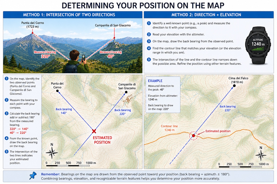
A classic method consists of identifying two clearly recognizable features on the terrain, such as a summit, a bell tower, an antenna or another distinctive point. By measuring with the compass the direction towards each feature and plotting the two directions on the map from the respective points, their intersection provides an estimate of your position.
Since the direction is measured from your position towards the observed point, the opposite direction must be plotted on the map, that is, the back azimuth. To obtain it, add or subtract 180° from the measured bearing, keeping the result within the range from 0° to 360°. To plot the direction accurately on the map, it is useful to use a protractor.
Direction and elevation
Another possibility is to combine the direction of a recognizable feature with your elevation. Knowing the direction towards the feature and the elevation indicated by the altimeter, contour lines allow you to identify areas on the map that are compatible with this information and narrow down the possible position.
In both cases, the result will be more reliable the more accurately the terrain features have been identified and the directions measured. Combining multiple pieces of information, such as directions, elevation, terrain shape and other recognizable points, makes it possible to obtain a more reliable position.
Determining your position with GPS
GPS allows you to determine your position through the coordinates received from satellites. A device can therefore display the position directly on the digital map, indicating where you are.
The position can be expressed using latitude and longitude or through coordinates belonging to a projected coordinate system. To correctly compare GPS coordinates with a map, it is therefore necessary to interpret the reference system correctly.
When using a paper map, the coordinates provided by GPS can be used to manually determine your position, provided that the map includes a grid compatible with the coordinate system used.
With a georeferenced digital map, on the other hand, the software can directly display the GPS position on the map, making it easy to compare the position with the terrain.
Comparing the GPS position with the terrain
Knowing where the GPS point is on the map is useful, but orientation should not be limited to simply observing the position. It is important to compare the position with the terrain morphology and with features that are actually visible.
Ridges, valleys, watercourses, roads, buildings, summits and other distinctive features can provide independent confirmation of the position indicated by GPS.
This approach is particularly useful when the position accuracy is not sufficient to distinguish between two nearby trails or when the map being used is not perfectly up to date.
Following a GPS track in the field
When you have a previously prepared GPS track, the device can display your position in relation to the planned route. This makes it possible to check whether you are correctly following the track and quickly identify any deviations.
However, it is important to distinguish between following a track and understanding the route. A line on the display does not necessarily indicate that the route is still passable, nor does it by itself provide sufficient information about the nature of the terrain.
The map therefore remains an important tool for interpreting what is around the track and for assessing possible alternatives in advance.
Even when the track has been prepared with great care, it is always advisable to check the actual situation in the field. A trail may have been modified, interrupted, become difficult to see or no longer be passable.
Using a map and GPS together
Map and GPS should not be considered alternative tools, but complementary ones. GPS is particularly effective for quickly determining your position, while the map allows you to understand the geographic context and plan possible directions.
During a hike, for example, you can:
- use GPS to determine your position;
- check your position on the map in relation to valleys, ridges, roads and trails;
- check your direction of travel;
- compare the planned route with the one actually followed;
- use the map to evaluate alternatives in the event of obstacles or deviations.
In this way, GPS becomes a navigation aid rather than the only source of information.
Direction of travel and GPS orientation
A fairly common mistake is to think that GPS always knows the direction in which the device is oriented. In reality, a normal GPS receiver can determine the direction of movement by comparing successive positions.
When you are stationary, this information may therefore not be meaningful: small errors in successive positions can produce an apparently changing direction.
During movement, on the other hand, the direction derived from the change in position becomes much more useful for determining the direction of travel.
Some devices also have a magnetic sensor that allows them to use an electronic compass. In this case, the device can determine the direction even when you are stationary, without having to derive the orientation from movement between two GPS positions. In this case too, it is important to understand the difference between magnetic direction and the geographic reference.
Orientation without an Internet connection
GPS positioning does not require an Internet connection. The receiver can determine its position using satellite signals even without a data connection.
To display a map during a hike without a connection, however, the map must already be available on the device, for example because it was downloaded previously or because it is a local map. To learn more about using offline maps, see the article Using offline maps for hiking.
This distinction is particularly important for outdoor activities: GPS and Internet access are two different things. GPS positioning is possible even where there is no mobile phone coverage, but it is not possible to download a new Web map at that moment if the device does not have a network connection.
Limitations and precautions
No orientation tool is infallible. GPS can have position errors, a compass can be affected by metal objects or magnetic fields, and a map may be outdated or not accurately represent the current situation.
It is therefore good practice to use multiple sources of information at the same time and not base an important decision on a single indication.
In particular, when travelling through mountainous or remote areas, it is advisable to keep an alternative method of orientation available and not rely exclusively on battery power or electronics.