OkMap Desktop Features: GPX editor and GPS itinerary planner
Plan routes, edit GPX files, georeference maps, use DEM elevation data and navigate with GPS. OkMap Desktop brings together all the tools you need for hiking, outdoor navigation, map management and GPS track analysis in a single application. OkMap Desktop can be used as a GPX editor, GPS route planner, and GPS track analysis software.
Download OkMap and start using these features today
Get started with OkMap Desktop. Download the software and discover how to plan routes, manage waypoints, analyze GPS tracks and work with online and offline maps.
Free Windows software - Complete PDF manual - Video tutorials - Articles
GPX Editor and Route Planning
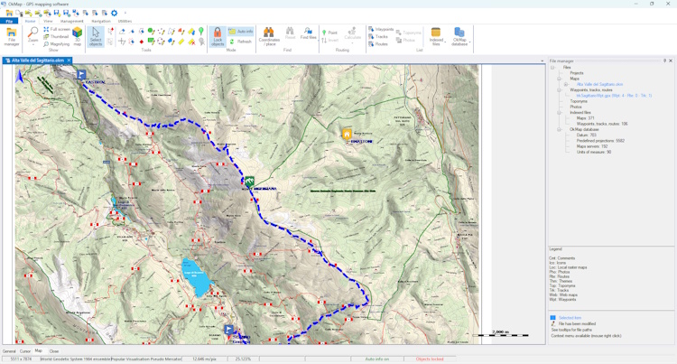
Create and manage GPS waypoints, routes, and tracks on online and offline maps. Import, edit and export GPX files, plan hiking and mountain biking routes and use OkMap as a GPS route planner and GPX editor to organize all your GPS data.
Main features include:
- Create and edit waypoints, routes and GPS tracks
- Automatic route planning, including trails and paths
- Import and export GPX files
- Search and organize GPS data
- Download waypoints from OpenStreetMap
Read the article
GPS Track Analysis and Statistics
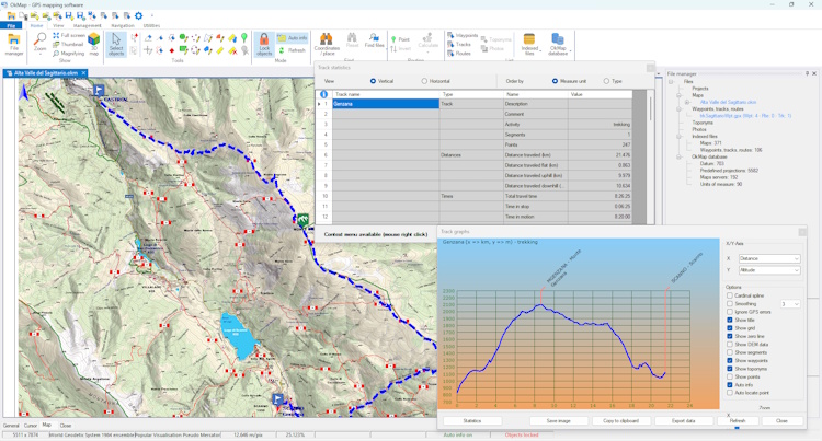
Analyze your GPS tracks with detailed statistics, elevation profiles and dedicated charts. Evaluate distance, elevation gain, speed and travel times using the built-in GPS track analysis tools.
Main features include:
- More than 60 statistical indicators
- Elevation profiles and dedicated charts
- Slope and elevation gain analysis
- Compare routes and activities
- Performance and travel time calculations
Read the article
Raster Map Georeferencing
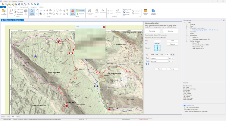
OkMap is a georeferencing software that allows you to transform scanned maps, images, and historical maps into georeferenced maps that can be used with real-world coordinates. The map georeferencing tools allow you to assign control points and integrate maps with GPS tracks and waypoints.
Main features include:
- Control-point based georeferencing
- Support for coordinate systems and EPSG codes
- Raster map rectification and correction
- Export georeferenced maps
- Use maps together with waypoints, routes and GPS tracks
Read the article
DEM Elevation Data and Terrain Models
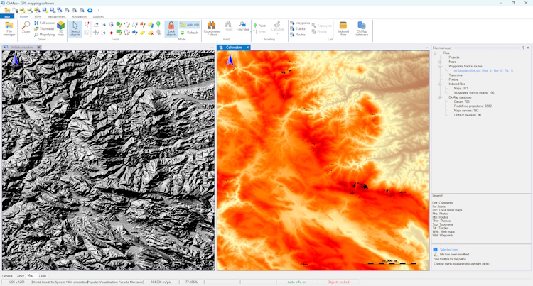
Use DEM elevation data and digital terrain models to obtain elevations, slopes and elevation profiles. Enrich GPS tracks and improve route planning for hiking and outdoor activities.
Main features include:
- Automatic download of SRTM elevation models
- Assign elevation data to GPS tracks
- Create elevation profiles
- Slope and elevation gain analysis
- Generate contour lines
Read the article
Garmin Custom Maps and GPS Devices
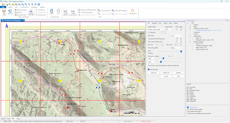
Create custom Garmin GPS maps in KMZ format. Transfer maps, waypoints, routes, and tracks to compatible GPS devices. OkMap simplifies GPS data management between computers, GPS navigators and mobile devices.
Main features include:
- Create Garmin Custom Maps (KMZ)
- Transfer waypoints, routes and tracks
- Compatibility with many Garmin GPS devices
- Convert between different GPS file formats
- Exchange data with mobile devices
Read the article
Web Maps and 3D Terrain Visualization
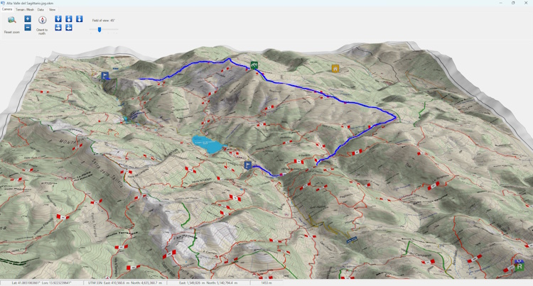
Access hundreds of online maps, satellite imagery and up-to-date topographic maps. Save maps to your computer and use them as offline maps for hiking and outdoor activities. View routes and waypoints in a 3D environment and explore the terrain with a realistic representation of your outdoor activities.
Main features include:
- Access to hundreds of web maps and satellite images
- Support for Tiled, WMS and WMTS maps
- Satellite imagery and topographic maps
- 3D terrain visualization
- Integration with Google Earth
Read the article
Complete Features of the OkMap GPX Editor
General Features
- Database with 703 EPSG datums
- Database with 5582 predefined EPSG coordinate system projections for geographic areas
- 15 of the most widely used map projections
- Display web maps from 192 map servers (Google, Apple, OpenStreetMap, ESRI, USGS, Kompass, IGM, ...)
- Italian Cadastre layers: buildings, parcels, overlays and zoning
- Support for adding custom web map servers
- Raster map calibration and display (more than 30 image formats)
- Vector map display
- Hybrid map display (raster + vector data, web maps + local raster maps)
- Open multiple maps simultaneously
- Coordinate display in: decimal degrees, degrees-minutes, degrees-minutes-seconds, UTM, ECEF, Open Location Code, GeoRef, USNG (US National Grid), MGRS (Military Grid Reference System), British Grid, Irish Grid, projected metric coordinates with custom projections
- 3D raster map visualization through Google Earth (for supported image formats)
- Project management
- Full-screen map display
- Map add-on management (icons, comments)
- Vector data management (points, multipoints, lines, polygons, pie charts)
- GPX data management (waypoints, tracks, routes)
- File manager
- Multiple object selection with the mouse
- Context menu (right mouse button)
- Auto-info function
- Zoom, autofit and zoom-to-selected-objects functions
- Map panning in different modes
- Docking forms
- Dark theme
- Customizable toolbar
- Show/hide toolbar
- Show/hide status bar
- Check for new releases at startup
Typical Applications
- Hiking and trekking
- Mountain biking
- Off-road navigation
- Skiing
- Boating and marine navigation
- Aviation
- Search and rescue
- Fire departments
- Law enforcement
- Airsoft
- Geocaching
- Field data collection
GPX Data (Waypoints, Routes and Tracks)
- Create and move GPX data with the mouse
- Create tracks in freehand mode
- Track drawing with slope-based colors
- Waypoint, route and track lists with attribute management
- Waypoint, route and track file indexing
- Search waypoints, routes and tracks
- Waypoint cluster management
- Track simplification
- Track smoothing
- Track elevation smoothing
- Track and route duplication
- Merge tracks and routes
- Merge track segments
- Split a track into multiple segments
- Split a track into multiple tracks
- Assign DEM elevation data to waypoints and tracks
- Load recently opened GPX data
- Merge GPX files
- Split a GPX file (save each track or route as a separate file)
- Copy selected GPX objects to another file
- Download waypoints from OpenStreetMap
Track Statistics
- Track statistics with more than 60 indicators
- Track elevation profile (18 chart types)
- Track performance charts based on multiple indicators
Vector Data (Points, Multipoints, Lines and Polygons)
- Vector layer list and attribute management
- Create and move vector data with the mouse
- Edit vector data attributes
- Delete vector data
- Import vector data from ESRI shapefiles
- Download vector data from OpenStreetMap
- Create contour lines on the map
Place Names
- Import place names from multiple sources (OziExplorer, Garmin POI, GPX)
- Create place names with the mouse
- Up to 3 classification levels
Photos
Map Add-ons (Icons, Comments)
- Create and move map add-ons with the mouse
- Edit map add-on attributes
- Delete map add-ons
Map Functions
- 3D visualization of raster maps and GPX data
- Distance and area calculations on the map
- Overview map (thumbnail) display
- Magnifier display
- Map indexing, listing and opening
- Meta-map function and map boundary display
- Map search function
- Print, save or copy map images to the clipboard
- Store map position and zoom level on exit
- Load recently opened maps
- Convert maps from one format to another
Coordinate Grids
- Latitude / longitude grid display
- Metric grid display
- Sub-grid display
Elevation Data
- Support for DEM data in SRTM, GeoTIFF and ASCII formats
- Display elevation at the current mouse position
- Automatic download of DEM data for the current map
- Display DEM boundaries on the map
Map Tiling and Garmin Custom Maps
- Automatic or manual configuration of tile count and tile size
- Optimization for Garmin Custom Maps and OruxMaps
- Select which tiles to generate
Map Management
- Rotate maps by a specified angle
- Crop map images
- Resize map images
- Reproject maps to a different coordinate system
- Merge two maps
GDAL Integration
- Load maps through GDAL
- Save maps through GDAL
- Map information
- SRS file information
- GDAL console
Map Download and Google Integration
- Download and save maps from map servers with automatic georeferencing
- 3D integration with Google Earth (maps + GPX data)
Web Service Features
- Autorouting function
- Geocoding function
- Integration with Google Earth, Google Maps, Google Places and Google Street View
- Integration with OpenStreetMap
- Route search on Wikiloc
- Geocache search on Geocaching.com
- Integration with Peakfinder
- Integration with other websites for weather, mapping and astronomy
Calculation and Conversion Tools
- Integration with the GpsBabel front-end
- Convert GPX data to vector data
- Convert vector data to GPX data
- Coordinate conversion tools
- Batch coordinate conversion tools
- Distance and azimuth conversion tools
- Distance calculation tool
- Area calculation tool
- Grid generator for search and rescue operations
GPS Navigation
Remote Devices and Servers
- Send tracks and waypoints to remote OkMap Server and OkMap Web Server devices (available separately by contacting info@okmap.org)
- Receive and display tracks and waypoints in real time from remote OkMap Server, OkMap Web Server, EasyTrails and OruxMaps devices
Supported Formats
Supported GPS Devices
- Upload/download: all modern GPS devices recognized as mass storage devices
- Upload/download: legacy GPS devices using proprietary protocols - see Supported GPS devices
- NMEA navigation: all GPS devices supporting the NMEA 0183 protocol
Supported Map Projections
- Albers Conical Equal Area
- Bonne
- Cassini
- Hotine Oblique Mercator
- Lambert Azimuthal Equal Area
- Lambert Conformal Conic
- Lambert Conformal Conic 2SP
- Longitude/Latitude (Equidistant Cylindrical / Plate Carrée)
- Mercator 1SP
- Mercator 2SP
- Mercator Spherical
- Oblique Mercator
- Orthographic
- Swiss Oblique Cylindrical
- Transverse Mercator
Supported Languages
 Chinese
 French
 German
 English
 Italian
 Russian
 Slovenian
 Spanish

Take OkMap Mobile into the field
Have you planned your route with OkMap Desktop? Transfer maps, waypoints and GPX routes to your Android smartphone and use OkMap Mobile for offline GPS navigation during your outdoor activities.
Video Tutorials
Learn how to use OkMap with a collection of step-by-step video tutorials.
Discover how to plan routes, manage GPS waypoints and tracks, georeference maps, use
DEM elevation data and take advantage of the program's main features.
Articles and Guides
Explore OkMap features in depth through technical articles and practical guides.
You'll find examples, tips and detailed procedures dedicated to GPS navigation, GPS track
analysis, route planning and map management.